La Thuile (Savoie)
| La Thuile | ||
|---|---|---|
|
|
||
| region | Auvergne-Rhône-Alpes | |
| Department | Savoie | |
| Arrondissement | Chambery | |
| Canton | Saint-Alban-Leysse | |
| Community association | Chambéry Métropole-Cœur des Bauges | |
| Coordinates | 45 ° 32 ' N , 6 ° 3' E | |
| height | 656-1,640 m | |
| surface | 18.26 km 2 | |
| Residents | 330 (January 1, 2017) | |
| Population density | 18 inhabitants / km 2 | |
| Post Code | 73190 | |
| INSEE code | 73294 | |
| Website | www.la-thuile.com/joomla | |
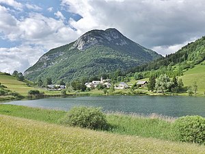
 View of La Thuile |
||
La Thuile is a French commune in the department of Savoie in the region of Auvergne Rhône-Alpes .
geography
La Thuile is located at 874 m above sea level, about 11 km east-southeast of the city of Chambéry (as the crow flies). The farming village extends in the west of the Savoie department, in the extreme south of the Bauges massif , in a valley basin on the Lac de la Thuile, at the southern foot of the Pic de la Sauge. The community is located within the Massif des Bauges Regional Nature Park .
The area of the 18.26 km² municipal area includes a section of the solid mass of the Bauges. The central part of the area is occupied by a basin with little relief, which averages 850 m and has a diameter of about 2.5 km. The more or less round basin is closed off in all directions except to the northwest. It is drained through the Ruisseau de Ternèze to the Leysse (tributary of the Lac du Bourget ). In the valley basin is the 7.3 hectare Lac de la Thuile. The basin is delimited on its south side by a sharp mountain ridge that drops very steeply towards the Isère valley furrow . Important peaks of this ridge are the Sommet de Montgelas ( 1300 m ), the Roche du Guet ( 1209 m ) and the Rochefort ( 1102 m ). To the north, the municipality extends into the headwaters of the Ruisseau de Ternèze in the area of the heights of Pic de la Sauge ( 1612 m ), Pointe de la Galoppaz (up to 1640 m, highest elevation of La Thuile) and Mont Charvet ( 1572 m ).
In addition to the actual town center, La Thuile also includes various hamlet settlements and farms, including:
- Monthoux ( 760 m ) on the Ruisseau de Ternèze at the exit from the La Thuile basin
- Morion ( 840 m ) in the middle of the valley basin
- Necuidet ( 800 m ) in the southern part of the basin
- La Rongère ( 860 m ) in the valley of the Ruisseau de Ternèze at the foot of the Pic de la Sauge
Neighboring municipalities of La Thuile are Puygros and Aillon-le-Jeune in the north, Saint-Jean-de-la-Porte and Cruet in the east, Montmélian and Porte-de-Savoie with Francin in the south and Chignin and Curienne in the west.
history
The La Thuile area belonged to the Bishop of Grenoble .
Attractions
The village church of La Thuile dates from the 19th century. The Lac de la Thuile is a natural attraction.
population
With 330 inhabitants (January 1, 2017), La Thuile is one of the small communities in the Savoie department. After the population fell sharply in the first half of the 20th century, a slight population increase has been recorded again since the beginning of the 1980s.
| Population development | |||||||
|---|---|---|---|---|---|---|---|
| year | 1962 | 1968 | 1975 | 1982 | 1990 | 1999 | 2009 |
| Residents | 261 | 242 | 198 | 197 | 229 | 258 | 283 |
Economy and Infrastructure
Until well into the 20th century, La Thuile was a village dominated by agriculture , mainly dairy farming and cattle breeding. In addition, there are now some local small businesses. Many employed people are commuters who work in the larger towns in the area, especially in the Chambéry area.
The village away from the major thoroughfares. Local road connections exist with Curienne, Puygros and Cruet. The closest connection to the A43 motorway is around 17 km away.
