Bauges
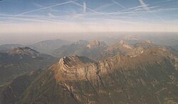
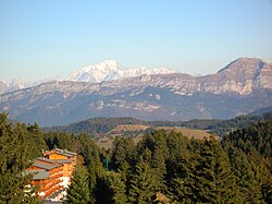
The Bauges are a pre-alpine mountain range made of limestone in the northern French Alps . The massif of the Bauges ( French Massif des Bauges , German often Bauget-Alpen ), the highest peak of which is the Pointe d'Arcalod at 2217 m , is located in the Savoie and Haute-Savoie departments . It is geographically assigned to the French Limestone Alps (Chaînes Subalpines Septentrionales) . The sparsely populated mountain area is located in the Regional Nature Park Massif des Bauges ( French Parc naturel régional du Massif des Bauges ).
location
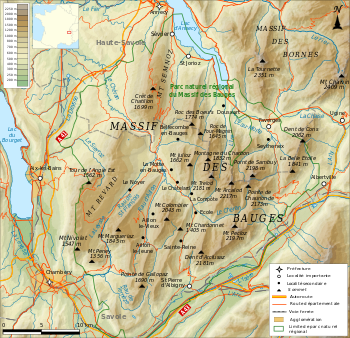
The Bauges are located in southeast France in the Auvergne-Rhône-Alpes region , in the triangle between the cities of Annecy , Chambéry and Albertville . They are clearly demarcated from the surrounding mountain ranges by wide valleys created by the Ice Age glaciers. To the west, the Bauges massif is bounded by the Molasse Basin of the Albanais and the southern part of the Lac du Bourget . In the southwest, the valley furrow of Chambéry separates the mountain range from the Chartreuse . The broad Isèretal and the valley of its tributary Arly form the natural demarcation from the predominantly crystalline high Alps in the southeast and east. In the north-east of the Bauges are the Alpine rim lake Lac d'Annecy and the Chaise valley (in the Isère catchment area), which are connected by a valley watershed. This valley furrow separates the Bauges from the north-east adjoining massif of the Bornes .
Geography and surface shape
The mountain complex of the Bauges shows an extension of about 30 km in the southwest-northeast direction with a width of 20 to a maximum of 25 km. The relief is characterized by a series of mountain ranges and intervening hollows and valleys that run parallel almost in a north-south direction. Only in the far east are mountain ranges nested in one another due to the stronger folds. The many steep rock faces, some of which fall vertically, are striking. From west to east the summit height increases more or less continuously. While the westernmost chain has heights between 1500 and 1700 m , the peaks in the middle and in the east of the massif often exceed the 2000 m limit. The highest point is the Pointe d'Arcalod with 2217 m . Other important peaks are:
- Pointe de la Sambuy , 2,198 m
- Mont Pécloz , 2,197 m
- Mont Trélod , 2,181 m
- Dent de Cons , 2,062 m
- Mont Colombier , 2,043 m
- Dent d'Arclusaz , 2,040 m
- Mont Margériaz , 1,845 m
- Roc des Boeufs , 1,774 m
- Crêt de Châtillon , 1,699 m
- Nivolet , 1,547 m
- Mont Revard , 1,537 m
The main river of the Bauges is the Chéran , a left tributary of the Fier . It rises in the area of the Pointe d'Arcalod and flows through the mountain range from southeast to northwest in a relatively wide hollow across the chain structure of the mountain range. It takes in various short side streams from the south and north, which drain the long valleys and hollows. Below Lescheraines , the Chéran enters the Cluse de Bange , a deep gorge that crosses the western rim ( Mont Revard , Semnoz ) before reaching the Albanais basin. The northern part of the Bauges is drained to Lac d'Annecy, the southwest to Lac du Bourget. Towards the southeast towards the Isèretal, the massif drops off with a steep slope; there are no valleys here, only short erosion channels that belong to the Isère catchment area.
geology
In structural and geological terms, the Bauges form a mountain range of folds on the edge of the Western Alps. They consist of a thick layer of Mesozoic sediments deposited in the Tethys Ocean . The sequence of layers extends from the lower Jurassic period (Lias, about 200 million years ago) to the Upper Cretaceous (about 65 million years ago). During this long period of time, numerous clayey and marly layers as well as limestone layers were sedimented. While the latter indicate conditions in a warm shallow sea, the marly layers mainly originate from periods with cooler water and at least partially deep-sea conditions (sediments were deposited in the deep sea). In the early Tertiary, sands, Nummulithenkalke and, especially in the western part, reddish marls (so-called molasse rouge ) lay on top .
In the course of the Tertiary, these sediment layers were lifted above sea level in the course of the folding of the Alps and pushed together to form a mountain of folds with characteristic anticlines and synclines . From this point on, erosion began and transported the rubble to the foothills of the Alps (the Molasse basin to the northwest of the Bauges). The various uplift and subsidence processes led to the formation of numerous faults , fault lines and displacements. During the Ice Ages , the glaciers made a significant contribution to modeling the relief.
From a stratigraphic and tectonic point of view, the Bauges massif is divided into a western ( Bauges occidentales ) and an eastern part ( Bauges orientales ). The border between the two parts forms a line that runs from Saint-Jorioz on Lake Annecy southwards over the Col de Leschaux and the Chéran to the Aillon valley .
The Bauges occidentales consist of the chain of Mont Revard and Semnoz and Mont Margériaz to the east of the former . Together with the Semnoz, the Mont Revard forms an anticline that is pushed onto the molasse sediments to the west. The two ridges are separated by the Cluse de Bange gorge . The rock in the crest area of this largely preserved anticline is composed of mighty limestone banks of the Urgonia (Middle Cretaceous). The Urgonia limestone also forms relief on Mont Margériaz. In the depression east of these ridges one can find layers of molasses and marl from the Old Tertiary.
The Bauges orientales show a rapid succession of anticlines and synclines. It is noteworthy that here the anticline folds have been eroded much more strongly than the syncline folds. Therefore, today various mountains are formed as so-called syncline mountains, while valleys or hollows often lead along anticlines. Examples of syncline mountains are the Mont Trélod , the Pointe d'Arcalod , the Pointe de la Sambuy and the Dent d'Arclusaz . Here, too, the Urgon Limestone form peaks. However, the further east you go, sediment layers from the Lower Cretaceous and Jurassic periods (especially the Tithon Limestone) emerge on the slopes and in the rock in the valley basins. In the far south-east and east between Saint-Pierre-d'Albigny and Albertville, layers of the Lias (lower Jurassic period) are also exposed on the lower slopes.
Natural and cultural landscape
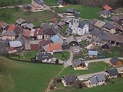
The Bauges massif is only sparsely populated. Larger cities and towns lie in the valley furrows on the edge of the Bauges, namely Annecy , Aix-les-Bains , Chambéry , Albertville , Ugine and Faverges . There are various scattered settlements and numerous individual farms in the valleys and hollows of the Bauges . However, no municipality has more than 1000 inhabitants. The central towns of the Bauges include Lescheraines , Le Châtelard , École and Aillon-le-Jeune .
The inhabitants, who call themselves Les Baujus , live mainly from dairy farming and cattle breeding , cheese production and the timber industry are also important. Meadows and pastures extend into the flatter basins, while the slopes are predominantly forest-covered. The tree line is around 1800 m , above which there are alpine meadows.
tourism
The mountains of the Bauges are suitable for winter sports and summer hikes or simply to relax in the natural landscape. Winter sports stations with ski and chair lifts are:
- Le Revard (about 1500 m ), which was established in 1905 as one of the first ski sports stations in France, is now also a center for Nordic skiing
- Les Aillons-Margériaz (1000 to 1800 m ), consisting of two ski stations that are now under joint management, namely Margériaz on the eastern slope of Mont Margériaz and Aillon-le-Jeune on the northern slope of Mont Pelat.
- Le Semnoz (1350 to 1700 m )
- Seythenex-Le Sambuy (1200 to 1800 m ), south of Faverges on the northern slope of the Pointe de la Sambuy.
Natural park
In December 1995 the Massif des Bauges Regional Nature Park was created to protect the rich flora and fauna of the mountain area. The regional nature park extends over an area of 810 km².
See also
Web links
- Massif des Bauges Regional Nature Park (French)
- Geology of the Massif des Bauges (French)


