
Lac du Bourget
| Lac du Bourget | ||
|---|---|---|

|
||
| Geographical location | Savoie , France | |
| Tributaries | Leysse, Tillet, Sierroz | |
| Drain | Canal de Savières → Rhone | |
| Places on the shore | Aix-les-Bains | |
| Data | ||
| Coordinates | 45 ° 44 ' N , 5 ° 52' E | |
|
||
| Altitude above sea level | 231.5 m | |
| surface | 44.5 km² | |
| length | 18 km | |
| width | 3.5 km | |
| volume | 3.6 km³ | |
| Maximum depth | 145 m | |
| Middle deep | 80.9 m | |

The Lac du Bourget (German Lake of Le Bourget ) is the largest natural lake that lies entirely within France . It is located in the north of the Savoie department . It is one of the postglacial lakes in the Alps and was formed after the last Würm Ice Age , around 19,000 years after the retreat of the great Quaternary glaciers . Due to its rich nature, the lake has also been a major tourist destination since the 19th century .
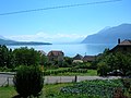
The lake has an area of around 44.5 km² and is approx. 18 km long. The lake, which lies in north-south direction, is a maximum of 3.5 km wide. The lake, which is 145 m deep, had never frozen over in living memory.
The western shore of the lake is formed by the southernmost foothills of the Jura Mountains . The range of hills is called Chaîne de l'Epine and culminates in the Dent du Chat ( 1390 m ) and drops steeply to the lake. The Chaîne de l'Epine protects the lake from bad weather influences from the west. This bank is only very sparsely populated.
The eastern bank is dominated by the Massif des Bauges . This massif culminates in Mont Revard 1538 m and is home to the nature park of the same name.
The lake is located in a 560 km² large plain. The largest cities on this level are the spa town of Aix-les-Bains on the south-east bank and Chambéry, about 10 km south of the lake . The municipality of Le Bourget-du-Lac on the south bank bears the name of the lake.
Emergence
Legend has it that Lac du Bourget, like Lac d'Annecy and Lake Geneva , were filled by the tears of three angels whom God commanded to leave the area of the foothills of the Alps.
As far as we know today, Lac du Bourget, like many other lakes in the foothills of the Alps, was formed with the melting of the Ice Age glaciers. About 130,000 to 140,000 years ago, a huge lake basin was pushed out as a typical tongue basin during the Saale / Riss glaciation .
The result was a lake that stretched from today's municipality of Seyssel (Haute-Savoie) in the north to Saint-Marcelin in the southwest. In addition, valley areas were covered up to what is now Albertville and parts of the Rhone Valley as far as Yenne . This Ursee had an area of approx. 1,000 km² and was 140 km long. The water level was around 360 m and thus around 120 m above today's level.
During the subsequent Würme Ice Age, the Ice Age Rhone Glacier and the Isère Glacier collided in the area of today's lake and cleared today's lake basin. This also resulted in today's approx. 50 km long valley between Seyssel, Yenne and Challes-les-Eaux .
Hydrology
With a water volume of 3.6 billion m³ (which corresponds to the annual drinking water consumption of private households in France), the lake served primarily as a flood overflow of the Rhône before 1982. Although this possibility is de facto no longer needed due to various barrages of the Rhône, the river is deliberately allowed to overflow once a year. The water level of the lake rises briefly by 1 meter.
The main tributary is the Leysse . Their mean discharge rate is given as 41.8 cubic meters per second.
Biology and Conservation
Between the 1950s and 1970s, the unsettled discharge of sewage from 170,000 residents, including the residents of Chambéry and an increasing number of tourists , endangered the water quality. The additional nutrient pollution led to eutrophication of the lake and the increasing shipping traffic endangered the fauna of the lake due to oil pollution and noise pollution.

Large parts of the inaccessible western shore are still in a near-natural state. Due to its mass of water and the limestone cliffs on the banks, a very moderate microclimate developed, which in very protected places already has Mediterranean features. You can therefore find the French maple , the fig tree , the common boxwood , the downy oak and the maiden in the green . The appellation wines Vin de Savoie and Roussette de Savoie , both of which are part of the Savoie wine-growing region, are also grown on its banks .
The lake has a beautiful population of seabirds and is located in an important bird migration passage . It is therefore possible on the lake, the mallard , the mute swan , the coot , the tufted duck , the little bittern , the avocet , the Goosander , the black kite , the peregrine and the eagle owl watching.
The reed belt of the lake
The lake's formerly dense stocks of reeds have declined significantly since the 1960s. Waves from motorized shipping and floating debris are two causes of danger. A protection zone was therefore set up in the extreme south of the lake, although a campsite with a beach is adjacent to it. To protect against drifting tree trunks and similarly large flotsam, the nature conservation organization FRAPNA ( Fédération régionale des associations de protection de la nature de Rhône-Alpes ) placed stakes in the water in front of the reed strips to stop the flotsam and serve as a seat for z. B. serve cormorants . In 2000, the European pond turtle , which had previously completely disappeared, was successfully released again.
The reeds offer protection to the kingfisher and also play an important role in maintaining fish stocks. In the depths of the lake, the European pike , roach , catfish , perch , carp and crested mucus live . In the shallower parts of the lake you'll find the lake trout , the whitefish , brown trout , rainbow trout and burbot . The aquarium in Aix-les-Bains offers an overview of the species diversity of the fish. The bezoule , a fish from the order of the salmon-like species, which was formerly endemic to the lake , was declared extinct by the IUCN in 2008.
tourism
In addition to fishing, various water sports such as swimming, water skiing, sailing or rowing are possible.

Historic attractions at Le Bourget-du-Lac include the Prieuré, an 11th-century monastery near St. Laurent's Church, and its gardens, and Château Thomas II, a 13th-century ruined castle. The abbey of Hautecombe , located on the hard-to-reach west coast, is best reached by boat from the opposite bank.
As a renowned spa and spa town, Aix-les-Bains offers a wide range of cultural activities with concerts, operettas and exhibitions. The Musée Faure houses an important collection of French impressionists. Alphonse de Lamartine , poet of French Romanticism , had already dedicated the poem Le Lac to the lake in the 19th century .
Shipping
The Lac du Bourget is connected to the Rhône in the northeast by a navigable canal. A shipping company is based in Aix-les-Bains and covers various tourist programs from 200-person party ships to individual explorers. Scheduled traffic does not play a role due to the lack of nodes. Motorized pleasure boats and sailing ships find anchorage in several ports around the lake.
gallery
The lake at Bourget-du-Lac


Aix-les-Bains

Épine and la Dent du Chat mountain range

Lac du Bourget

Lac du Bourget

Lac du Bourget


