
Massif des Bauges regional nature park


The Regional Natural Park of the Bauges ( fr. Parc naturel régional du Massif des Bauges ) is located in the French region of Auvergne Rhône-Alpes and extending into the departments of Haute-Savoie and Savoie .
The park is located roughly between the cities
- Annecy in the north,
- Albertville in the east,
- Chambéry in the southwest and
- Aix-les-Bains to the west.
Park management
.JPG)
The nature park was founded on December 7, 1995. The park currently covers an area of around 85,600 hectares. The park administration with the "Maison du Parc" is based in Le Châtelard ( 45 ° 41 ′ 11 ″ N , 6 ° 8 ′ 12 ″ E, ) . 63 municipalities (as of January 1, 2018) with a catchment area of around 70,400 inhabitants make up the park, further municipalities are associated with the nature park as "access points".
The nature park is from since September 17, 2011 UNESCO under the brand name Geopark Bauges as a UNESCO Global Geopark excellent. This designation stands for the great geological importance of a territory and contributes to the tourist and economic development of the area, taking into account the required sustainability . The impressive karst forms and the elevated synclines in the Bauges massif were two geological trump cards for the candidacy.
Larger places in the park
In the Haute-Savoie department
In the Savoie department

View of Doussard

in the center of Faverges
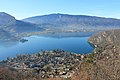
Place Tallores, municipality of Saint-Jorioz, on Lake Annecy

Sévrier, Town Hall Square

-rues.JPG)


View of Mercury

Old town of Montmélian

Miolans castle, parish of Saint-Pierre-d'Albigny

_1.JPG)

landscape
The nature park encompasses the entire limestone massif of the Bauges massif and extends down into the adjacent valleys and also has a share of Lac d'Annecy in the north . It forms an island of protected nature, where the villages, which mostly crouch between grassland and forests , are often surrounded by mountain peaks towering 2,000 meters . These mountains preserve remarkable flora and fauna of around 1300 species of plants, 150 species of breeding birds , 9 species of amphibians . A nature reserve in the center provides habitat for chamois , mouflons and black grouse . One of the peculiarities of the rural heritage, which reveals the way of life and its development, is based on its diversity: The massif is formed by many small areas that are rich in identity and have maintained an intensive cultural and economic exchange with one another for centuries .
This territory offers great opportunities for discovery: the nature park can be explored on foot, on horseback , with a donkey , by bike , on a paraglider , on skis or snowshoes . After the core zone of Bauges, the discovery of its valleys, bocage landscapes , vineyards on the lakes and the large Alpine valleys should not be missing. Residents offer products that make their pride: primarily the Tome de Bauges - cheese ( AOC ) without the apples , the pears , the honey , the aromatic and medicinal plants, the goat cheese and the white and red wines of To forget the erosion valleys of Savoy .
Higher mountain peaks
- Pointe d'Arcalod (2217 m),
- Mont Pécloz (2191 m),
- Mont Trélod (2181 m),
- Mont d'Arménaz (2158 m),
- Pointe des Arces (2076 m),
- Mont de la Coche (2065 m),
- Pointe des Arlicots (2060 m),
- Dent d'Arclusac (2041 m),
- Montagne du Semnoz with the Crêt du Châtillon (1699 m),
- Montagne du Charbon with the Lanche Close (1791 m).
Waters
- Catchment area of Lake Annecy south of Annecy ,
- Catchment area of the Arly , right tributaries between Ugine and Albertville ,
- Catchment area of the Isère , right tributaries between Albertville and Montmélian ,
- Lac du Bourget with inlets at Aix-les-Bains ,
- Catchment area of the Chéran in the northeast.
gallery

Dent de l'Arclusaz (2041 m)

Mont Trélod (2181 m)

Pointe d'Arcalod (2217 m)

Dent des Portes (1932 m)

Cow husbandry on the Montagne de Semnoz
.JPG)
.jpg)

.jpg)
.jpg)

Nature reserve at the southern end of Lake Annecy

Eau morte, tributary of Lake Annecy

The Isère at the foot of the Bauges massif
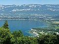
View of the Lac du Bourget with the Bauges massif in the background

Suspension bridge over the Chéran river


.JPG)


The village of Cléry

View of La Thuile

View of the Bauges massif near Verel-Pragondran

Vineyards near Chignin , on the left the Bauges massif

Vineyards near Apremont , on the left the Bauges massif

.JPG)
.JPG)
.JPG)

See also
Web links
- Natural park website (French)