
Cruet
| Cruet | ||
|---|---|---|
|
||
| region | Auvergne-Rhône-Alpes | |
| Department | Savoie | |
| Arrondissement | Chambery | |
| Canton | Saint-Pierre-d'Albigny | |
| Community association | Coeur de Savoie | |
| Coordinates | 45 ° 32 ' N , 6 ° 6' E | |
| height | 272-1,456 m | |
| surface | 10.06 km 2 | |
| Residents | 1,038 (January 1, 2017) | |
| Population density | 103 inhabitants / km 2 | |
| Post Code | 73800 | |
| INSEE code | 73096 | |
| Website | www.cruet.fr | |
.JPG) Cruet |
||

Cruet is a French commune with 1,038 inhabitants (as of January 1 2017) within the arrondissement Chambéry in the department of Savoie in the region of Auvergne Rhône-Alpes . The municipality belongs to the canton of Saint-Pierre-d'Albigny .
geography
Cruet is about 14 kilometers east-southeast of Chambéry an der Isère . Cruet is surrounded by the neighboring communities of La Thuile in the north and west, Saint-Jean-de-la-Porte in the north and northeast, Coise-Saint-Jean-Pied-Gauthier in the east, Planaise in the south, Arbin in the southwest and Montmélian in the west and southwest. The community is located within the Massif des Bauges Regional Nature Park .
Population development
| year | 1962 | 1968 | 1975 | 1982 | 1990 | 1999 | 2006 | 2017 |
| Residents | 508 | 457 | 525 | 638 | 823 | 969 | 1044 | 1038 |
| Sources: Cassini and INSEE | ||||||||
Attractions
- Saint-Laurent Church, built between 1896 and 1899
- Verdun-Dessus Castle, former castle from the 13th century
- La Rive Castle, former castle from the 13th century
- Le Chaffard tower from the 14th century
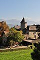
Verdun-Dessus Castle
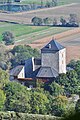
La Rive Castle

Le Chaffard tower


Web links
Commons : Cruet - collection of images, videos and audio files