Méry (Savoie)
| Méry | ||
|---|---|---|
|
|
||
| region | Auvergne-Rhône-Alpes | |
| Department | Savoie | |
| Arrondissement | Chambery | |
| Canton | La Motte-Servolex | |
| Community association | Grand Lac - Lac du Bourget | |
| Coordinates | 45 ° 39 ′ N , 5 ° 56 ′ E | |
| height | 272-1,000 m | |
| surface | 9.07 km 2 | |
| Residents | 1,803 (January 1, 2017) | |
| Population density | 199 inhabitants / km 2 | |
| Post Code | 73420 | |
| INSEE code | 73155 | |
| Website | www.mery73.fr | |
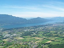
 The municipality of Méry in front of Mont Revard |
||
Méry is a French commune with 1,803 inhabitants (at January 1, 2017) in the department of Savoie in the region of Auvergne Rhône-Alpes . It belongs to the canton of La Motte-Servolex in the Arrondissement of Chambéry .
geography
Méry is located at 360 m , about nine kilometers north of the city of Chambéry (as the crow flies). The village extends in the north-west of the Savoie department, on the western edge of the Bauges massif and at the foot of Mont Revard , slightly elevated on the edge of a valley floor that runs parallel to the Chambéry valley, near Lac du Bourget .
The area of the 9.07 km² municipal area comprises a section in the Alpine foothills. The main part of the area is occupied by a wide, formerly marshy depression, which is drained from the Tillet north to the Lac du Bourget. In the west the border runs along the canalised Tillet. From here the community area extends eastward over the 1.5 km wide valley floor and the gently sloping slope of Méry. This is followed by the wooded steep slope ( Bois du Fournet ) of Mont Revard. This steep slope is dominated by a striking rock face, the upper edge of which forms the eastern border. Here, at around 1000 m, Méry's highest elevation is reached.
In addition to the actual town center, Méry also includes several hamlet settlements and farms, including:
- Les Jacquiers ( 285 m ) in the Tillet valley
- Fournet ( 310 m ) at the foot of Mont Revard
Neighboring municipalities of Méry are Drumettaz-Clarafond in the north, Verel-Pragondran in the east and Sonnaz and Viviers-du-Lac in the west.
history
Méry was first mentioned in a document in the 9th century under the name Mariacum . In the 12th century, the Bishop of Grenoble gave the town to the Priory of Saint-Jeoire, and in the 13th century Méry came into the possession of the Hautecombe monastery .
Attractions
The village church of Méry was built in the 19th century. At the edge of the forest above the village is the Château Revers with a chapel.
population
| Population development | |
|---|---|
| year | Residents |
| 1962 | 425 |
| 1968 | 410 |
| 1975 | 391 |
| 1982 | 591 |
| 1990 | 666 |
| 1999 | 1,183 |
| 2006 | 1,274 |
| 2016 | 1,706 |
With 1803 inhabitants (as of January 1, 2017), Méry is one of the smaller communities in the Savoie department. After the population declined in the first half of the 20th century, there has been a marked increase in population since the mid-1970s thanks to the attractive residential area. Since then, the number of inhabitants has tripled.
Economy and Infrastructure
Méry was a predominantly agricultural village well into the 20th century . Thanks to its central location in the greater Aix-les-Bains-Chambéry area, over a thousand jobs have now been created in the municipality, especially in the inter-municipal industrial and commercial park Savoie Hexapole, which was opened in 1999 . At the same time, the village has developed into a residential community, and the majority of those in employment in the village are commuters who work in the Chambéry area.
The place is well developed in terms of traffic. It is located on a departmental road that leads from Chambéry to Mouxy . Other road connections exist with Sonnaz and Viviers-du-Lac. The nearest connection to the A41 motorway , which crosses the municipality, is around 6 km away.
Web links
- Official website of the municipality of Méry (French)
- Official website of the Savoie-Hexapole Business Park (French)
Individual evidence
- ↑ bottom Présentation on the website of the municipality.
- ^ JJ Vernier: Dictionnaire topographique du département de la Savoie . Imprimerie Savoisienne, 1896, p. 501 (French, online on BNF [accessed January 19, 2014]).
- ↑ French Statistics Institute ( www.insee.fr )
- ↑ Méry - notice communale. In: cassini.ehess.fr. Retrieved October 20, 2014 (French).
- ^ Complete dossier on Méry. In: INSEE . Retrieved October 20, 2014 (French).

