Belmont Tramonet
| Belmont Tramonet | ||
|---|---|---|
|
|
||
| region | Auvergne-Rhône-Alpes | |
| Department | Savoie | |
| Arrondissement | Chambery | |
| Canton | Le Pont-de-Beauvoisin | |
| Community association | Val Guiers | |
| Coordinates | 45 ° 34 ′ N , 5 ° 41 ′ E | |
| height | 219-360 m | |
| surface | 5.46 km 2 | |
| Residents | 561 (January 1, 2017) | |
| Population density | 103 inhabitants / km 2 | |
| Post Code | 73330 | |
| INSEE code | 73039 | |
| Website | www.belmont-tramonet.fr | |
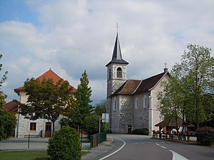
 Mayor's office ( Mairie ) and village church of Belmont-Tramonet |
||
Belmont-Tramonet is a French municipality with 561 inhabitants (at January 1, 2017) in the department of Savoie in the region of Auvergne Rhône-Alpes . It belongs to the canton of Le Pont-de-Beauvoisin in the Arrondissement of Chambéry . The municipality is also a member and administrative seat of the Val Guiers municipal association .
geography
location
Belmont-Tramonet is located on the western edge of the department at 271 m , about 19 kilometers west of the prefecture of Chambéry , 69 kilometers east-southeast of the city of Lyon and 42 kilometers north of the city of Grenoble (as the crow flies). Neighboring municipalities of Belmont-Tramonet are Saint-Genix-les-Villages with Saint-Genix-sur-Guiers in the north, Avressieux and Verel-de-Montbel in the east, Domessin in the south and Romagnieu ( Département Isère ) in the west.
topography
The area of the 5.46 km 2 municipality covers part of the Avant-Pays Savoyard , the Savoyard foreland characterized by gentle elevations between the border river Guiers and the southern end of the main anticlines of the Jura . The communal soil, with a slight relief, reaches its highest elevation in the east at 360 m and slopes down to the west to the valley of the Guiers, which forms the western boundary of the commune. It is drained by two small brooks that flow into the Guiers. The community is a scattered settlement , the majority of which is used for agriculture. It is divided into Tramonet in the north, Belmont in the south and a small industrial area halfway between the two places.
history
In Roman times, the road from Aoste to Chambéry led across the area of today's municipality with the help of a bridge over the Guiers, of which foundations made of limestone blocks have still been preserved.
During the High Middle Ages , Belmont first appeared in the 11th century as a description of the origin of Joffredus de Bellomonte . A parish responsible for both villages, Belmont and Tramonet, was mentioned in 1208 ( Ecclesia de Belmont et de Tremunnai ). Just like in numerous other places with the same name, Belmont means something like "beautiful mountain". The independent parish of Tramoney , documented in the 14th century, was merged with Belmont again in 1803.
Attractions
In the center there is a Gallo-Roman votive stone , which is classified as a monument historique . It is dedicated to Jupiter . In addition to the village church of Belmont from the 19th century, Tramonet has a chapel, the origins of which go back to the Middle Ages, when Tramonet was an independent parish. The Château de Belmont from the 13th century, this since 1972 Convent of the Benedictine Order under the name Abbaye de la Rochette . The convent had existed from 1824 at La Rochette in Caluire-et-Cuire near Lyon and went back to Thérèse de Bavoz .
population
| Population development | |
|---|---|
| year | Residents |
| 1962 | 313 |
| 1968 | 287 |
| 1975 | 348 |
| 1982 | 341 |
| 1990 | 339 |
| 1999 | 405 |
| 2006 | 501 |
| 2011 | 561 |
With 561 inhabitants (as of January 1, 2017) Belmont-Tramonet is one of the small communities in the Savoie department. After the population initially declined after the annexation of Savoy to France (576 inhabitants were counted in 1861), it remained at just over 300 during the 20th century. The population has increased again in recent years. The local residents of Belmont-Tramonet are called Belmontois (es) in French .
Economy and Infrastructure
Belmont-Tramonet is still a predominantly agricultural village, whose farmers are mainly focused on milk production . In addition, there are now various local small businesses and some medium-sized businesses. In the meantime the village has also developed into a residential community. Many employed people are commuters who work in the larger towns in the area and in the neighboring departments.
The village is located away from the major thoroughfares in a network of departmental roads that connect it with its neighboring communities. A motorway connection to the A43 ( Lyon –Chambéry) is located in the municipality. The airports in the region are Lyon-St-Exupéry (65 km away) and Chambéry-Savoie (32 km away).
Web links
Individual evidence
- ↑ Le pont romain. In: Official website of the municipality of Romagnieu . Retrieved May 3, 2015 .
- ↑ A. Gros: Dictionnaire étymologique des noms de lieu de la Savoie . Belley, Imprimerie Aimé Chaduc, 1937, p. 57 (French, limited preview in Google Book search).
- ^ JJ Vernier: Dictionnaire topographique du département de la Savoie . Imprimerie Savoisienne, 1896, p. 711 (French, online on BNF [accessed January 19, 2014]).
- ^ Gallo-Roman inscription in the base Palissy of the French Ministry of Culture (French).
- ↑ French Statistics Institute ( www.insee.fr )
- ↑ Belmont-Tramonet - notice communale. In: cassini.ehess.fr. Retrieved on April 26, 2015 (French, INSEE population from 1968 ).
- ^ Complete dossier on Belmont-Tramonet. In: INSEE . Retrieved April 26, 2015 (French).


