Saint-Pierre-d'Entremont (Savoie)
| Saint-Pierre-d'Entremont | ||
|---|---|---|
|
|
||
| region | Auvergne-Rhône-Alpes | |
| Department | Savoie | |
| Arrondissement | Chambery | |
| Canton | Le Pont-de-Beauvoisin | |
| Community association | Coeur de Chartreuse | |
| Coordinates | 45 ° 25 ' N , 5 ° 51' E | |
| height | 598–2,047 m | |
| surface | 18.36 km 2 | |
| Residents | 457 (January 1, 2017) | |
| Population density | 25 inhabitants / km 2 | |
| Post Code | 73670 | |
| INSEE code | 73274 | |
| Website | www.saintpierredentremont.org | |
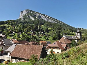
 View of Saint-Pierre-d'Entremont |
||
Saint-Pierre-d'Entremont is a French municipality with 457 inhabitants (as of January 1 2017) in the department of Savoie in the region of Auvergne Rhône-Alpes . It belongs to the canton of Le Pont-de-Beauvoisin (until 2015: canton of Les Échelles ) in the Arrondissement of Chambéry and is a member of the Cœur de Chartreuse community .
geography
Saint-Pierre-d'Entremont is located on the western edge of the department at about 650 m , about 17 kilometers southwest of the prefecture of Chambéry and about 17 kilometers north-northeast of the city of Grenoble (as the crow flies). The Guiers Vif limits the municipality to the south. Neighboring municipalities of Saint-Pierre-d'Entremont are Entremont-le-Vieux in the north, Sainte-Marie-du-Mont in the east, Saint-Bernard in the south and southeast, Saint-Pierre-d'Entremont in the south, Saint-Christophe- sur-Guiers in the west and Corbel in the west and northwest.
Population development
| year | Residents |
|---|---|
| 1962 | 346 |
| 1968 | 333 |
| 1975 | 342 |
| 1982 | 295 |
| 1990 | 294 |
| 1999 | 372 |
| 2006 | 416 |
| 2013 | 417 |
Attractions
- Saint-Alexis church from the 19th century
- Montbel Castle

