Curienne
| Curienne | ||
|---|---|---|
|
|
||
| region | Auvergne-Rhône-Alpes | |
| Department | Savoie | |
| Arrondissement | Chambery | |
| Canton | Saint-Alban-Leysse | |
| Community association | Chambéry Métropole-Cœur des Bauges | |
| Coordinates | 45 ° 34 ' N , 6 ° 1' E | |
| height | 360-1,290 m | |
| surface | 8.55 km 2 | |
| Residents | 682 (January 1, 2017) | |
| Population density | 80 inhabitants / km 2 | |
| Post Code | 73190 | |
| INSEE code | 73097 | |
| Website | www.curienne.com | |
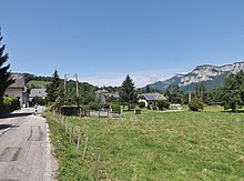
 Mayor's office ( Mairie ) of Curienne against the backdrop of the Pointe de la Galoppaz |
||
Curienne is a French municipality with 682 inhabitants (at January 1, 2017) in the department of Savoie in the region of Auvergne Rhône-Alpes . It belongs to the canton of Saint-Alban-Leysse and the Arrondissement Chambéry .
geography
Curienne is located at 712 m , about seven kilometers east of the city of Chambéry (as the crow flies). The former farming village extends in the west of the Savoie department, in the southern part of the Bauges massif , on a high plateau in front of the actual mountain massif, high above the Leysse valley .
The area of the 8.55 km² large municipal area includes a section of the solid mass of the Bauges. The central part of the area is occupied by the Plateau de la Leysse , which is on average at an altitude of around 750 m . The plateau is dominated by Mont Saint-Michel ( 895 m ) in the south . It drops off steeply to the west to the Chambéry valley basin. In the north it is bordered by the deeply cut valley of the Leysse (tributary of the Lac du Bourget ) and in the east by the valley of its side stream Ruisseau de Ternèze . To the south, the municipal area extends over the valley of Fornet to the mountain ridge of the Sommet de Montgelas , on which the highest point of Curienne is reached at 1300 m .
In addition to the actual town center, Curienne also includes various hamlet settlements and farmsteads, including:
- Boyat ( 680 m ) on a saddle east of Mont Saint-Michel
- Fornet ( 600 m ) in a valley between Mont Saint-Michel and Sommet de Montgelas
- Montmerlet ( 840 m ) on the northeastern roof of Mont Saint-Michel
Neighboring municipalities of Curienne are Saint-Jean-d'Arvey in the north, Puygros and La Thuile in the east, Chignin and Saint-Jeoire-Prieuré in the south and Challes-les-Eaux and Barby in the west. The municipality lies within the Regional Nature Park Massif des Bauges (French: Parc naturel régional du Massif des Bauges ).
history
The parish of Curienne was first mentioned in writing around 1100 as Coruana and later Corvenna . Until 1973 the municipality was part of the administrative canton of Chambéry-Nord , after which it moved to the newly founded canton of Saint-Alban-Leysse.
Attractions
The village church of Saint-Maurice was built in the 19th century in the neo-Gothic style, but has no bell tower. The Saint-Michel chapel, built in 1879, stands on Mont Saint-Michel, which offers an impressive view of Chambéry and the surrounding mountain ranges. The previous building, of which the foundations are still visible, served as an important pilgrimage destination.
population
| Population development | |
|---|---|
| year | Residents |
| 1962 | 190 |
| 1968 | 157 |
| 1975 | 240 |
| 1982 | 415 |
| 1990 | 524 |
| 1999 | 613 |
| 2007 | 646 |
With 682 inhabitants (as of January 1, 2017) Curienne is one of the small communities in the Savoie department. After the number of inhabitants declined in the first half of the 20th century, a significant increase in population has been recorded again since the beginning of the 1970s thanks to the beautiful residential area.
Economy and Infrastructure
Until well into the 20th century, Curienne was a village dominated by agriculture , mainly dairy farming and cattle breeding. In addition, there are now some local small businesses. Many employed people are commuters who work in the larger towns in the area, especially in the Chambéry area.
The village is located off the main thoroughfares on a departmental road that leads from Barby to La Thuile. There are other local road connections with Saint-Jean-Prieuré and Puygros. The closest connection to the A43 motorway is around 11 km away.
Web links
Individual evidence
- ↑ A. Gros: Dictionnaire étymologique des noms de lieu de la Savoie . Belley, Imprimerie Aimé Chaduc, 1937, p. 148 (French, limited preview in Google Book search).
- ↑ French Statistics Institute ( www.insee.fr )
- ^ Curienne - notice communale. In: cassini.ehess.fr. Retrieved September 4, 2014 (French).
- ^ Complete dossier on Curienne. In: INSEE . Retrieved September 3, 2014 (French).


