
Col des Champs
| Col des Champs | |||
|---|---|---|---|
 Col des Champs |
|||
| Compass direction | west | east | |
| Pass height | 2087 m | ||
| Department | Alpes-de-Haute-Provence | Alpes-Maritimes | |
| Watershed | Verdon | Var | |
| Valley locations | Colmars | Saint-Martin-d'Entraunes | |
| expansion | D2 | D78 | |
| Mountains | Maritime Alps | ||
| profile | |||
| Mountain scoring | 1 | HC | |
| Ø pitch | 7% (860 m / 12.5 km) | 6.5% (1050 m / 16.3 km) | |
| map | |||
|
|||
| Coordinates | 44 ° 10 ′ 41 ″ N , 6 ° 42 ′ 6 ″ E | ||

The Col des Champs mountain pass in the French Maritime Alps connects the town of Colmars in the Verdon Valley with the town of Saint-Martin-d'Entraunes in the Var valley in the Provence-Alpes-Côte d'Azur region . It is a connection from the Col d'Allos to the Col de la Cayolle . On the 2087 m high pass summit, which marks the border between the Alpes-Maritimes and Alpes-de-Haute-Provence departments , there is no inn or refuge.
Infrastructure
The road over the pass is paved throughout, but the descent from the summit to Colmars is very narrow and in the upper area there are many deep gullies. In the further course the asphalt is in a very bad condition in parts. There are many bumps, potholes and gravel. The asphalt was only renewed on the last seven to eight kilometers before Colmars (as of August 2015). The side between the summit and Saint-Martin-d'Entraunes is in good condition (as of August 2015).
The French long-distance hiking trail GR 52A also leads over the Col des Champs and connects Colmars with Entraunes .
Road cycling
Together with the Col d'Allos and the Col de la Cayolle, the Col des Champs forms a popular circuit for racing cyclists. The ascent from Colmars is marked with special signs for cyclists at intervals of approximately one kilometer .
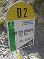
One of the special mileage markers for cyclists on the Colmars climb

literature
- Sabine Bade, Wolfram Mikuteit, Grande Randonnée 52A. Le Sentier panoramique du Mercantour . Fernwege.de, Roxheim 2008, ISBN 978-3-937304-78-6 .
Individual evidence
- ↑ Cayolle-Champs-Allos - Bikemap - Your bike routes online . bikemap.net. Retrieved August 11, 2015.
Agnel • Allos • Andrion • Aravis • Bonette • Braus • Cayolle • Champs • Colle-Saint-Michel • Colombière • Croix de Fer • Croix-Fry • Cuillole • Galibier • Gets • Glandon • Granon • Iseran • Izoard • Jambaz • Joux Plane • Joux Verte • Larche • Lautaret • Lebraut • Lombarde • Madeleine • Saint Martin • Méraillet • Mollard • Mont Cenis • Montets • Montgenèvre • Morgins • Moutière • Ornon • Pré • Petit Saint-Bernard • Pontis • Ramaz • Roselend • Rousset • Saisies • Télégraphe • Tende • Turini • Valberg • Vars