
Guillestre
| Guillestre | ||
|---|---|---|

|
|
|
| region | Provence-Alpes-Cote d'Azur | |
| Department | Hautes-Alpes | |
| Arrondissement | Briançon | |
| Canton | Guillestre (main town) | |
| Community association | Guillestrois et Queyras | |
| Coordinates | 44 ° 40 ′ N , 6 ° 39 ′ E | |
| height | 867-2,694 m | |
| surface | 51.29 km 2 | |
| Residents | 2,344 (January 1, 2017) | |
| Population density | 46 inhabitants / km 2 | |
| Post Code | 05600 | |
| INSEE code | 05065 | |

Guillestre is a French commune with 2,344 inhabitants (as of January 1, 2017) in the French Alps in the Hautes-Alpes department .
geography
Guillestre is located on a 1000 m high plateau above the gorge of the Guil River , which flows into the Durance a few kilometers below . It is located on the Route des Grandes Alpes and is the starting point for trips to the Alpine passes Col de Vars , Col d'Izoard and Col Agnel . Parts of the municipality belong to the Queyras Regional Nature Park . The location of the place also offers easy access to several ski areas, for example in Risoul , Vars or Queyras . The town of Mont-Dauphin (which is a UNESCO World Heritage Site) is also in the vicinity.
history
Guillestre was first mentioned in the 12th century as a property of the bishops of Embrun . It looks back on an eventful history and was affected by the Italian-French wars due to its location on the border with Italy . This is why the place also had a fortress, and the city gates are still a reminder of those times. During the Wars of Religion , Guillestre was attacked on September 5, 1587 by the Protestant military leader François de Bonne, duc de Lesdiguières . On July 30, 1692, Viktor Amadeus II of Savoy captured the city after a three-day siege.


Mayor is Bernard Leterrier; his term of office was extended in 2014 and ends in 2020. He succeeds Armand Jallut, who held the office from 2001 to March 2008. As a middle center for the surrounding holiday resorts, Guillestre lives mainly from summer and winter tourism.
Population development
| year | 1962 | 1968 | 1975 | 1982 | 1990 | 1999 | 2006 | 2016 |
| Residents | 1,448 | 1,479 | 1,466 | 1.937 | 2,000 | 2.211 | 2,276 | 2,314 |
| Sources: Cassini and INSEE | ||||||||
Attractions
The Saint-Guillaume chapel was built in the 11th century. The "Tour d'Eygliers" is part of the medieval city fortifications and overlooks the old town. The town church "Notre-Dame d'Aquilon" was built in the first half of the 16th century and is decorated by two reclining lions on the north portal.
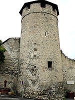
The tower d'Eygliers
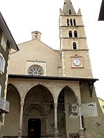
Notre-Dame d'Aquilon church


Web links
Individual evidence
- ↑ Le Patrimoine de Guillestre on ville-guillestre.fr, accessed on February 20, 2015.
- ^ Joseph Hyppolyte Roman: Dictionnaire topographique du département des Hautes-Alpes . Imprimerie Nationale, Paris, 1884, p. 78 (French, online on BNF [accessed February 20, 2015]).
- ↑ De 1500 a 1789 on queyras.aparcourir.com, accessed on February 20, 2015 (PDF)
- ^ Geoffrey Symcox: Victor Amadeus II. Absolutism in the Savoyard State, 1675-1730. University of California Press, Berkeley 1983, ISBN 0-520-04974-8 , p. 111. ( online )