
Arvieux
| Arvieux | ||
|---|---|---|

|
|
|
| region | Provence-Alpes-Cote d'Azur | |
| Department | Hautes-Alpes | |
| Arrondissement | Briançon | |
| Canton | Guillestre | |
| Community association | Guillestrois et Queyras | |
| Coordinates | 44 ° 46 ′ N , 6 ° 44 ′ E | |
| height | 1,138-2,910 m | |
| surface | 72.62 km 2 | |
| Residents | 365 (January 1, 2017) | |
| Population density | 5 inhabitants / km 2 | |
| Post Code | 05350 | |
| INSEE code | 05007 | |
 Arvieux |
||

Arvieux is a French commune in the Hautes-Alpes in the region of Provence-Alpes-Cote d'Azur . It belongs to the Arrondissement Briançon and the Canton of Guillestre (until 2015 Canton of Aiguilles ).
geography
The municipality belongs to the Queyras Regional Nature Park . The neighboring communities are Cevrières in the north, Château-Ville-Vieille in the east, Guillestre in the south-east, Eygliers in the south-west, Saint-Crépin and La Roche-de-Rame in the west and Villar-Saint-Pancrace in the north-west.
Population development
| year | 1962 | 1968 | 1975 | 1982 | 1990 | 1999 | 2005 | 2006 | 2012 |
|---|---|---|---|---|---|---|---|---|---|
| Residents | 413 | 412 | 324 | 351 | 338 | 355 | 347 | 348 | 371 |
Attractions
- Churches St-Laurent and Ste-Marie-Madeleine, both as historique monument classified
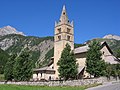
St Laurent Church
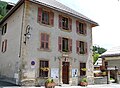
Mairie (Town Hall)

Lac Roue


Web links
Commons : Arvieux - collection of images, videos and audio files