
Saint-Chaffrey
| Saint-Chaffrey | ||
|---|---|---|

|
|
|
| region | Provence-Alpes-Cote d'Azur | |
| Department | Hautes-Alpes | |
| Arrondissement | Briançon | |
| Canton | Briançon-1 | |
| Community association | Briançonnais | |
| Coordinates | 44 ° 56 ' N , 6 ° 36' E | |
| height | 1,274–2,413 m | |
| surface | 25.88 km 2 | |
| Residents | 1,604 (January 1, 2017) | |
| Population density | 62 inhabitants / km 2 | |
| Post Code | 05330 | |
| INSEE code | 05133 | |
 Mairie Saint-Chaffrey |
||

Saint-Chaffrey (in Occitan Sant Chafrèi ) is a French commune in the Hautes-Alpes in the region of Provence-Alpes-Cote d'Azur . It belongs to the Arrondissement of Briançon and the Canton of Briançon-1 .
geography
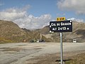
The village is located at 1365 m in the valley of the Guisane river . The Col de Granon is a 2413 m high pass in Saint-Chaffrey.
The neighboring communities are:
- Val-des-Prés in the northeast,
- Briançon and Puy-Saint-Pierre in the southeast,
- Puy-Saint-André in the southwest,
- La Salle-les-Alpes in the north-west.
Population development
| year | 1962 | 1968 | 1975 | 1982 | 1990 | 1999 | 2008 | 2012 |
|---|---|---|---|---|---|---|---|---|
| Residents | 844 | 831 | 947 | 1,287 | 1,424 | 1,569 | 1,662 | 1,663 |
Attractions
- House with sundial in Zarbula, Monument historique
- Saint-Arnould church, Monument historique
- Saint-Chaffrey Church, Monument historique
Col du Granon

Saint-Chaffrey church


Web links
Commons : Saint-Chaffrey - Collection of images, videos and audio files