
Le Monetier-les-Bains
| Le Monetier-les-Bains | ||
|---|---|---|

|
|
|
| region | Provence-Alpes-Cote d'Azur | |
| Department | Hautes-Alpes | |
| Arrondissement | Briançon | |
| Canton | Briançon-1 | |
| Community association | Briançonnais | |
| Coordinates | 44 ° 59 ′ N , 6 ° 31 ′ E | |
| height | 1,397-3,659 m | |
| surface | 97.87 km 2 | |
| Residents | 1,056 (January 1, 2017) | |
| Population density | 11 inhabitants / km 2 | |
| Post Code | 05220 | |
| INSEE code | 05079 | |
 Le Monetier-les-Bains |
||

Le Monêtier-les-Bains is a French commune in the Hautes-Alpes in the region of Provence-Alpes-Cote d'Azur . It belongs to the canton of Briançon-1 in the arrondissement of Briançon .
geography
Le Monêtier-les-Bains borders:
- in the north on Valloire ,
- in the northeast at Nevache ,
- in the southeast at La Salle-les-Alpes ,
- in the south at Vallouise-Pelvoux with Pelvoux ,
- to the west at Villar-d'Arêne ,
- to the northwest at La Grave .
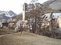
The village is at 1500 m .
Population development
| year | 1962 | 1968 | 1975 | 1982 | 1990 | 1999 | 2006 | 2007 | 2012 |
|---|---|---|---|---|---|---|---|---|---|
| Residents | 734 | 806 | 832 | 970 | 987 | 1009 | 1062 | 1066 | 1011 |
Attractions
- Notre-Dame-de-l'Assomption church
- Saint-André church
- Saint-Claude-du-Casset church
- Saint-Esprit des Guibertes church
- Saint Martin Church
- Saint-Pierre Chapel
The aforementioned structures are all historical monuments .

Notre-Dame-de-l'Assomption church
Saint-Claude-du-Casset church

Saint-Esprit des Guibertes church

Saint-Pierre Chapel


Web links
Commons : Le Monêtier-les-Bains - Collection of images, videos and audio files