
Queyras Regional Natural Park

The Queyras Regional Nature Park ( French: Parc naturel régional du Queyras ) is located in the French Hautes-Alpes department in the Provence-Alpes-Côte d'Azur region . The park extends between the Italian border with the Piedmont region, which runs in a north-south direction, and the Durance river valley, which runs parallel to the west . The next larger towns are Briançon in the north-west and Sestriere in the north of the nature park.
Park management
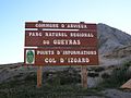
The nature park was founded on January 31, 1977 and covers an area of around 57,400 hectares. The park administration is based in Arvieux ( 44 ° 46 ′ 0 ″ N , 6 ° 44 ′ 21 ″ E ), where the “Maison du Parc “Is located. Ten municipalities with a catchment area of around 2,500 inhabitants make up the park.
Parishes in the park

- Abriès
- Aiguilles
- Arvieux
- Château-Ville-Vieille
- Ceillac
- Eygliers
- Guillestre
- Molines-en-Queyras
- Ristolas
- Saint-Véran
landscape
The Queyras is a mountain landscape in the catchment area of the river Guil , which reaches the valley level of the river Durance at Guillestre at an altitude of about 900 meters, into which it finally flows. If you follow the river in a north-easterly direction upwards, you pass the Gorges du Guil and Combe du Queyras until you reach the middle valley location of around 1400 meters at Château-Ville-Vieille . Here larger valleys lead north and south, but the main valley also continues and you reach the last larger places in the nature park at around 1700 to 2000 meters.
The landscape is completely surrounded by mountains in the north, east and south. In the east, the Cottian Alps lie on the border with Italy with the summit of Monte Viso ( 3841 m ), which, however, is already just beyond the border. The Réserve Naturelle Ristolas Mont-Viso protection zone is located in the nature reserve . The somewhat "smaller" mountain ranges in the north and south of the nature park also reach over 3000 meters.
In addition to the main connecting route in the valleys, there are two pass roads over the Col d'Izoard ( 2360 m ) to Briançon and over the Col Agnel ( 2744 m ) into the Valle Varaita (Italy).

Eygliers in the Durance Valley
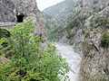
Georges du Guil

River Guil

Château Queyras
At the Col d'Izoard
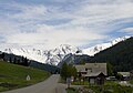
Molines-en-Queyras

Saint-Véran in winter

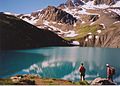
Lacs du Malrif, Aiguille
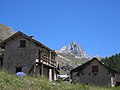
Valpréveyre, Abriès

Monte Viso, view from Col de Chamoussière

Road over the Col Agnel
Lac Sainte Anne, Ceillac


Flora and fauna
Winter conditions last more than nine months of the year above an altitude of 2,400 m . The mild periods of time suitable for the development of the plants are so reduced by this fact that many species can only rarely produce their seeds. The edelweiss in particular has adapted to this situation very well, as many parts of the plant are covered with white woolly hair to protect them from the cold. The grassy slopes, but also the larch forests, provide a habitat for chamois , ibex and mouflon . A shooting schedule in each municipality specifies the number of animals that can be hunted in autumn to regulate the population. The biotope is also home to a large number of marmots that defy the poor conditions in their hibernation until around the end of March and then live in large family groups. Again and again they become prey of the golden eagle .
See also
Web links
- Natural park website (French)