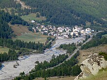
Ristolas
| Ristolas | ||
|---|---|---|

|
|
|
| local community | Abriès-Ristolas | |
| region | Provence-Alpes-Cote d'Azur | |
| Department | Hautes-Alpes | |
| Arrondissement | Briançon | |
| Coordinates | 44 ° 46 ′ N , 6 ° 57 ′ E | |
| Post Code | 05460 | |
| Former INSEE code | 05120 | |
| Incorporation | 1st January 2019 | |
| status | Commune déléguée | |
 Tower of the Saint-Marcellin church |
||
Ristolas is a village and a former French municipality with 86 inhabitants (at January 1, 2017) in the Hautes-Alpes in the region of Provence-Alpes-Cote d'Azur . It belonged to the Arrondissement of Briançon and the Canton of Guillestre .
With effect from January 1, 2019, the former municipalities of Abriès and Ristolas were merged to form the Commune nouvelle Abriès-Ristolas and have the status of a Commune déléguée in the new municipality . The administrative headquarters are in Abriès.
geography
Ristolas is the easternmost town in the Hautes-Alpes department. It is located in the valley of the Guil , about 30 kilometers southeast of Briançon . The eastern border lies on the main Alpine ridge , which forms the state border with Italy here. The former municipality belongs to the Queyras Regional Nature Park .
Population development
| year | 1962 | 1968 | 1975 | 1982 | 1990 | 1999 | 2007 | 2016 |
| Residents | 49 | 350 | 68 | 52 | 72 | 70 | 93 | 80 |
| Sources: Cassini and INSEE | ||||||||

