Bonneval-sur-Arc
| Bonneval-sur-Arc | ||
|---|---|---|
|
|
||
| region | Auvergne-Rhône-Alpes | |
| Department | Savoie | |
| Arrondissement | Saint-Jean-de-Maurienne | |
| Canton | Modane | |
| Community association | Haute Maurienne Vanoise | |
| Coordinates | 45 ° 22 ' N , 7 ° 3' E | |
| height | 1,759-3,642 m | |
| surface | 82.72 km 2 | |
| Residents | 261 (January 1, 2017) | |
| Population density | 3 inhabitants / km 2 | |
| Post Code | 73480 | |
| INSEE code | 73047 | |
| Website | www.bonneval-sur-arc.com | |
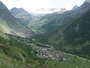
 Bonneval in the Haute-Maurienne valley |
||
Bonneval-sur-Arc is a French commune in the department of Savoie in the region of Auvergne Rhône-Alpes . It has 261 inhabitants (as of January 1, 2017) on an area of 82.72 km² and is classified as one of the Plus beaux villages de France ( Most Beautiful Villages in France ).
geography
Bonneval-sur-Arc is the easternmost municipality in the Savoie department. It is part of the Vanoise National Park and lies at 1835 meters in the Arc Valley , which flows here through the Maurienne landscape . The distance is 43 kilometers from Modane train station in a north-easterly direction and around 30 kilometers in a south-south-east direction from Val-d'Isère . The road to the Col de l'Iseran (2764 meters above sea level, the highest pass road in Europe that can be driven on ) begins in Bonneval-sur-Arc and leads to Val-d'Isère. This pass, which has often been included in the route of the Tour de France , connects the Maurienne landscape with the Tarentaise .
Long-distance and long-distance hiking trails
Bonneval-sur-Arc is a stop on the long-distance hiking trails GR 5 ( La grande Traversée des Alpes français ) and GR 5E ( Chemin du Petit Bonheur ).
Web links
Individual evidence
- ↑ Bonneval-sur-Arc on Les plus Beaux Villages de France (French)
