
Saint François Longchamp
| Saint François Longchamp | ||
|---|---|---|
|
||
| region | Auvergne-Rhône-Alpes | |
| Department | Savoie | |
| Arrondissement | Saint-Jean-de-Maurienne | |
| Canton | Saint-Jean-de-Maurienne | |
| Community association | Canton de La Chambre | |
| Coordinates | 45 ° 25 ′ N , 6 ° 21 ′ E | |
| height | 808-2,832 m | |
| surface | 60.68 km 2 | |
| Residents | 517 (January 1, 2017) | |
| Population density | 9 inhabitants / km 2 | |
| Post Code | 73130 | |
| INSEE code | 73235 | |
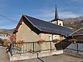
 Town hall ( Mairie ) of Saint François Longchamp |
||

Saint François Longchamp is a French municipality with 517 inhabitants (at January 1, 2017) in the department of Savoie in the region of Auvergne Rhône-Alpes (before 2016 Rhône-Alpes ). It belongs to the arrondissement of Saint-Jean-de-Maurienne and the canton of Saint-Jean-de-Maurienne (until 2015 La Chambre ). The inhabitants are called Inversaires .
The municipality was created with effect from January 1, 2017 as Commune nouvelle by amalgamating the previously independent municipalities of Saint-François-Longchamp , Montaimont and Montgellafrey . To differentiate between the earlier and today's congregation, this is now written without hyphens.
structure
| District | former INSEE code |
Area (km²) | Population (2016) |
|---|---|---|---|
| Montaimont | 73163 | 28.35 | 123 |
| Montgellafrey | 73167 | 19.36 | 78 |
| Saint-François-Longchamp (administrative headquarters) | 73235 | 12.97 | 288 |
geography
Saint François Longchamp is located about 43 kilometers southeast of Chambéry and about 51 kilometers east-northeast of Grenoble on the Bugéon . The area is a large ski area. Saint François Longchamp is surrounded by the neighboring communities of Épierre in the north and north-west, La Léchère in the north and north-east, Les Avanchers-Valmorel in the north-east, Saint-Jean-de-Belleville in the east, La Tour-en-Maurienne with Pontamafrey-Montpascal in the south , Saint-Avre to the south-west, Saint-Martin-sur-la-Chambre and Notre-Dame-du-Cruet to the west and south-west, Les Chavannes-en-Maurienne to the west and La Chapelle to the west and north-west.
history
In 1904, what was then the commune of Saint-François-Longchamp was formed from the localities of Envers Epalud , Planey , Covatières , Bon-Mollard and La Cublière by being separated from the commune of Montgellafrey .
Population development
| Location / year | 1962 | 1968 | 1975 | 1982 | 1990 | 1999 | 2006 1 | 2008 2 | 2011 1 | 2013 2 |
| Montaimont | 382 | 249 | 191 | 128 | 132 | 136 | 151 | 65 | 66 | 157 |
| Montgellafrey | 266 | 194 | 150 | 89 | 78 | 77 | 68 | 215 | 227 | 65 |
| Saint-François-Longchamp | 132 | 223 | 159 | 221 | 236 | 194 | 211 | 155 | 159 | 245 |
| Saint-François-Longchamp | 780 | 666 | 500 | 438 | 446 | 407 | 430 | 435 | 452 | 467 |
Attractions
Saint-François-Longchamp
- Chapel of Sainte-Anne
Montaimont
- Montaimont Church
- Notre-Dame chapels in Beaurevers, Saint-Bernard chapel in Methon and Sainte-Marguerite chapel
Montgellafrey
- Saint-Théodule church, historic monument since 1944
- Les Charmettes chapel

Montaimont Church

Notre-Dame chapel in Beaurevers
Saint-Théodule church in Montgellafrey


.JPG)
Web links
Individual evidence
- ↑ Population figures retrospectively from January 1, 2016
- ↑ Populations légales 2006 & 2011 & 2016
- ↑ Populations légales 2008 & 2013
- ↑ Des villages de Cassini aux communes d'aujourd'hui - Index par département