
Sainte-Marie-de-Cuines
| Sainte-Marie-de-Cuines | ||
|---|---|---|
|
||
| region | Auvergne-Rhône-Alpes | |
| Department | Savoie | |
| Arrondissement | Saint-Jean-de-Maurienne | |
| Canton | Saint-Jean-de-Maurienne | |
| Community association | Canton de La Chambre | |
| Coordinates | 45 ° 20 ′ N , 6 ° 18 ′ E | |
| height | 447-2,136 m | |
| surface | 14.95 km 2 | |
| Residents | 803 (January 1, 2017) | |
| Population density | 54 inhabitants / km 2 | |
| Post Code | 73130 | |
| INSEE code | 73255 | |
 Mairie Sainte-Marie-de-Cuines |
||

Sainte-Marie-de-Cuines is a commune in the Savoy in France . It belongs to the region -Rhône-Alpes Auvergne , the Savoie department for Arrondissement Saint-Jean-de-Maurienne and Canton Saint-Jean-de-Maurienne .
geography
Sainte-Marie-de-Cuines is located on the Glandon and borders in the northwest with Saint-Étienne-de-Cuines , in the northeast with Saint-Avre , in the east with Montvernier , in the southeast with La Tour-en-Maurienne with Pontamafrey-Montpascal , im South with Jarrier and southwest with Saint-Alban-des-Villards .
The nearest train stations are in Saint-Avre and La Chambre on the Culoz – Modane railway line .

The hamlet of Bonvoisin with a small chapel
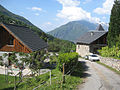
Champ-Fleury
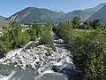
The river Glandon

Notre-Dame-de-l'Assomption Church, Monument historique


.JPG)

Population development
| year | 1962 | 1968 | 1975 | 1982 | 1990 | 1999 | 2008 | 2014 |
|---|---|---|---|---|---|---|---|---|
| Residents | 552 | 529 | 527 | 524 | 510 | 573 | 747 | 817 |