
Saint-Avre
| Saint-Avre | ||
|---|---|---|
.svg)
|
|
|
| region | Auvergne-Rhône-Alpes | |
| Department | Savoie | |
| Arrondissement | Saint-Jean-de-Maurienne | |
| Canton | Saint-Jean-de-Maurienne | |
| Community association | Canton de La Chambre | |
| Coordinates | 45 ° 21 ′ N , 6 ° 19 ′ E | |
| height | 443-1,229 m | |
| surface | 3.64 km 2 | |
| Residents | 868 (January 1, 2017) | |
| Population density | 238 inhabitants / km 2 | |
| Post Code | 73130 | |
| INSEE code | 73224 | |

Saint-Avre is a commune in the Savoy in France . It belongs to the region of Auvergne Rhône-Alpes , the Savoie department , the district Saint-Jean-de-Maurienne and Canton Saint-Jean-de-Maurienne . The residents call themselves Saint-Avrains.
geography
The Glandon flows on the border with Saint-Étienne-de-Cuines in the west as a left tributary into the Arc . The common station with La Chambre in the north-west is served by SNCF with the Culoz – Modane railway line.
The other neighboring communities are Saint-Martin-sur-la-Chambre in the north, Montvernier in the east and Sainte-Marie-de-Cuines in the south and south-west.
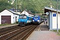
Saint-Avre − La Chambre train station

Mairie Saint-Avre

Saint-Alban Church


Population development
| year | 1962 | 1968 | 1975 | 1982 | 1990 | 1999 | 2008 | 2015 |
|---|---|---|---|---|---|---|---|---|
| Residents | 529 | 568 | 579 | 619 | 627 | 646 | 785 | 868 |
Web links
Commons : Saint-Avre - Collection of images, videos and audio files