
Culoz – Modane railway line
| Culoz – Modane | |||||||||||||||||||||||||||||||||||||||||||||||||||||||||||||||||||||||||||||||||||||||||||||||||||||||||||||||||||||||||||||||||||||||||||||||||||||||||||||||||||||||||||||||||||||||||||||||||||||||||||||||||||||||||||||||||||||||||||||||||||||||||||||||||||||||||||||||||||||||||||||||||||||||||||||||||||||||||||||||||||||||||||||||||||||||||||||||||||||||||||||||||||||||||||||||||||||||||||||||||||||||||||||||||||||||||||||||||||||||||||||||||||||||||||||||||||||||||||||||
|---|---|---|---|---|---|---|---|---|---|---|---|---|---|---|---|---|---|---|---|---|---|---|---|---|---|---|---|---|---|---|---|---|---|---|---|---|---|---|---|---|---|---|---|---|---|---|---|---|---|---|---|---|---|---|---|---|---|---|---|---|---|---|---|---|---|---|---|---|---|---|---|---|---|---|---|---|---|---|---|---|---|---|---|---|---|---|---|---|---|---|---|---|---|---|---|---|---|---|---|---|---|---|---|---|---|---|---|---|---|---|---|---|---|---|---|---|---|---|---|---|---|---|---|---|---|---|---|---|---|---|---|---|---|---|---|---|---|---|---|---|---|---|---|---|---|---|---|---|---|---|---|---|---|---|---|---|---|---|---|---|---|---|---|---|---|---|---|---|---|---|---|---|---|---|---|---|---|---|---|---|---|---|---|---|---|---|---|---|---|---|---|---|---|---|---|---|---|---|---|---|---|---|---|---|---|---|---|---|---|---|---|---|---|---|---|---|---|---|---|---|---|---|---|---|---|---|---|---|---|---|---|---|---|---|---|---|---|---|---|---|---|---|---|---|---|---|---|---|---|---|---|---|---|---|---|---|---|---|---|---|---|---|---|---|---|---|---|---|---|---|---|---|---|---|---|---|---|---|---|---|---|---|---|---|---|---|---|---|---|---|---|---|---|---|---|---|---|---|---|---|---|---|---|---|---|---|---|---|---|---|---|---|---|---|---|---|---|---|---|---|---|---|---|---|---|---|---|---|---|---|---|---|---|---|---|---|---|---|---|---|---|---|---|---|---|---|---|---|---|---|---|---|---|---|---|---|---|---|---|---|---|---|---|---|---|---|---|---|---|---|---|---|---|---|---|---|---|---|---|---|---|---|---|---|---|---|---|---|---|---|---|---|---|---|---|---|---|---|---|---|---|---|---|---|---|---|---|---|---|---|---|---|---|---|---|---|---|---|---|---|---|---|---|---|---|---|---|---|---|---|---|---|---|---|---|---|---|---|---|---|---|---|---|---|---|---|---|---|---|---|---|---|---|---|---|---|---|---|---|---|---|---|---|---|---|---|---|---|---|---|---|---|---|---|---|---|---|---|---|
 | |||||||||||||||||||||||||||||||||||||||||||||||||||||||||||||||||||||||||||||||||||||||||||||||||||||||||||||||||||||||||||||||||||||||||||||||||||||||||||||||||||||||||||||||||||||||||||||||||||||||||||||||||||||||||||||||||||||||||||||||||||||||||||||||||||||||||||||||||||||||||||||||||||||||||||||||||||||||||||||||||||||||||||||||||||||||||||||||||||||||||||||||||||||||||||||||||||||||||||||||||||||||||||||||||||||||||||||||||||||||||||||||||||||||||||||||||||||||||||||||
| Route number (SNCF) : | 900,000 | ||||||||||||||||||||||||||||||||||||||||||||||||||||||||||||||||||||||||||||||||||||||||||||||||||||||||||||||||||||||||||||||||||||||||||||||||||||||||||||||||||||||||||||||||||||||||||||||||||||||||||||||||||||||||||||||||||||||||||||||||||||||||||||||||||||||||||||||||||||||||||||||||||||||||||||||||||||||||||||||||||||||||||||||||||||||||||||||||||||||||||||||||||||||||||||||||||||||||||||||||||||||||||||||||||||||||||||||||||||||||||||||||||||||||||||||||||||||||||||||
| Course book route (SNCF) : | 512 | ||||||||||||||||||||||||||||||||||||||||||||||||||||||||||||||||||||||||||||||||||||||||||||||||||||||||||||||||||||||||||||||||||||||||||||||||||||||||||||||||||||||||||||||||||||||||||||||||||||||||||||||||||||||||||||||||||||||||||||||||||||||||||||||||||||||||||||||||||||||||||||||||||||||||||||||||||||||||||||||||||||||||||||||||||||||||||||||||||||||||||||||||||||||||||||||||||||||||||||||||||||||||||||||||||||||||||||||||||||||||||||||||||||||||||||||||||||||||||||||
| Route length: | 135 km | ||||||||||||||||||||||||||||||||||||||||||||||||||||||||||||||||||||||||||||||||||||||||||||||||||||||||||||||||||||||||||||||||||||||||||||||||||||||||||||||||||||||||||||||||||||||||||||||||||||||||||||||||||||||||||||||||||||||||||||||||||||||||||||||||||||||||||||||||||||||||||||||||||||||||||||||||||||||||||||||||||||||||||||||||||||||||||||||||||||||||||||||||||||||||||||||||||||||||||||||||||||||||||||||||||||||||||||||||||||||||||||||||||||||||||||||||||||||||||||||
| Gauge : | 1435 mm ( standard gauge ) | ||||||||||||||||||||||||||||||||||||||||||||||||||||||||||||||||||||||||||||||||||||||||||||||||||||||||||||||||||||||||||||||||||||||||||||||||||||||||||||||||||||||||||||||||||||||||||||||||||||||||||||||||||||||||||||||||||||||||||||||||||||||||||||||||||||||||||||||||||||||||||||||||||||||||||||||||||||||||||||||||||||||||||||||||||||||||||||||||||||||||||||||||||||||||||||||||||||||||||||||||||||||||||||||||||||||||||||||||||||||||||||||||||||||||||||||||||||||||||||||
| Power system : | 1500 V = | ||||||||||||||||||||||||||||||||||||||||||||||||||||||||||||||||||||||||||||||||||||||||||||||||||||||||||||||||||||||||||||||||||||||||||||||||||||||||||||||||||||||||||||||||||||||||||||||||||||||||||||||||||||||||||||||||||||||||||||||||||||||||||||||||||||||||||||||||||||||||||||||||||||||||||||||||||||||||||||||||||||||||||||||||||||||||||||||||||||||||||||||||||||||||||||||||||||||||||||||||||||||||||||||||||||||||||||||||||||||||||||||||||||||||||||||||||||||||||||||
| Maximum slope : | 30 ‰ | ||||||||||||||||||||||||||||||||||||||||||||||||||||||||||||||||||||||||||||||||||||||||||||||||||||||||||||||||||||||||||||||||||||||||||||||||||||||||||||||||||||||||||||||||||||||||||||||||||||||||||||||||||||||||||||||||||||||||||||||||||||||||||||||||||||||||||||||||||||||||||||||||||||||||||||||||||||||||||||||||||||||||||||||||||||||||||||||||||||||||||||||||||||||||||||||||||||||||||||||||||||||||||||||||||||||||||||||||||||||||||||||||||||||||||||||||||||||||||||||
| Top speed: | 150 km / h | ||||||||||||||||||||||||||||||||||||||||||||||||||||||||||||||||||||||||||||||||||||||||||||||||||||||||||||||||||||||||||||||||||||||||||||||||||||||||||||||||||||||||||||||||||||||||||||||||||||||||||||||||||||||||||||||||||||||||||||||||||||||||||||||||||||||||||||||||||||||||||||||||||||||||||||||||||||||||||||||||||||||||||||||||||||||||||||||||||||||||||||||||||||||||||||||||||||||||||||||||||||||||||||||||||||||||||||||||||||||||||||||||||||||||||||||||||||||||||||||
| Dual track : | continuous | ||||||||||||||||||||||||||||||||||||||||||||||||||||||||||||||||||||||||||||||||||||||||||||||||||||||||||||||||||||||||||||||||||||||||||||||||||||||||||||||||||||||||||||||||||||||||||||||||||||||||||||||||||||||||||||||||||||||||||||||||||||||||||||||||||||||||||||||||||||||||||||||||||||||||||||||||||||||||||||||||||||||||||||||||||||||||||||||||||||||||||||||||||||||||||||||||||||||||||||||||||||||||||||||||||||||||||||||||||||||||||||||||||||||||||||||||||||||||||||||
|
|||||||||||||||||||||||||||||||||||||||||||||||||||||||||||||||||||||||||||||||||||||||||||||||||||||||||||||||||||||||||||||||||||||||||||||||||||||||||||||||||||||||||||||||||||||||||||||||||||||||||||||||||||||||||||||||||||||||||||||||||||||||||||||||||||||||||||||||||||||||||||||||||||||||||||||||||||||||||||||||||||||||||||||||||||||||||||||||||||||||||||||||||||||||||||||||||||||||||||||||||||||||||||||||||||||||||||||||||||||||||||||||||||||||||||||||||||||||||||||||
The Culoz – Modane railway line , also known as the Maurienne line because it runs through the Maurienne , is a double-track railway line in the Auvergne-Rhône-Alpes region of France . It connects Culoz on the Lyon – Genève railway with the French border town of Modane towards Italy . The route is the western entrance to the Mont-Cenis tunnel and is continued on the Italian side by the Modane – Turin railway line , making it part of the Mont-Cenis railway, a main route in international passenger and freight traffic between France and Italy.
history
Emergence
In 1815 the Congress of Vienna decided to return the Duchy of Savoy , which had been annexed by France since 1792, to the Kingdom of Sardinia .
From 1830, when the first main lines of the French railway network were built, the discussion began about railway projects to connect the duchy to the international railway network and for a connection between France and future Italy. These projects made it imperative to cross the main Alpine ridge between Piémont with the Sardinian seat of government Turin and Savoy. In August 1839 , the customs agent and later building contractor Joseph François Médail from Bardonecchia submitted a first proposal to Charles Albert , King of Sardinia-Piedmont, for the construction of a tunnel under the Fréjus Pass. The railway leading through the Maurienne valley was supposed to connect the capital of the Duchy of Chambéry with the seat of government of the kingdom in Turin. However, Médail died in 1844 without receiving an answer to his suggestion.
Another decade passed before the Compagnie du chemin de fer Victor-Emmanuel was founded according to the royal decree of Victor Emmanuel II of May 25, 1853 . The railway company entrusted the English construction company Jackson, Brassey and Henfrey with the construction of the first single-track section between Choudy near Aix-les-Bains and Saint-Jean-de-Maurienne . Work began immediately and the 80 km section was inaugurated on October 20, 1856.
During the Sardinian War in 1859, in which the French army under Napoleon III. fought on the side of the kingdom, the railroad was used to transport troops to the front of the Battle of Magenta , in which the Austrians were defeated on April 4, 1858 . A secret treaty signed on July 21, 1858 between Camillo Cavour , the head of government of the Kingdom of Sardinia, and France provided for the cession of Savoy to France. Although Napoleon III waived. Following the preliminary peace signed by Villafranca on July 8, 1859, to take over Savoy and the county of Nice , but annexed Savoy on June 14, 1860, after a majority of the population had decided to join France in a referendum.
These events had a significant impact on the new railway line to be built in France. An imperial decree of May 27, 1863 confirmed the agreement between the Minister for Public Works and the Compagnie du chemin de fer Victor-Emmanuel that the concession of the railway company would continue to exist, but in accordance with two further agreements of June 9, 1866 and March 17 , 1863 June 1867, the railway company had to leave all sections of the route built on French soil and still to be built to the French state, which in turn sold them to the Compagnie Paris-Lyon-Méditerranée (PLM). These agreements came into force on September 27, 1867 by an imperial decree.
Because of the slow progress in the construction of the Mont-Cenis railway tunnel between Modane and Bardonecchia, the chief engineer M. Brassey proposed the construction of a provisional railway from Saint-Michel-de-Maurienne over the Col du Mont Cenis to Susa. This line, which was used by Fell locomotives , went into operation on June 15, 1868 and was closed again on September 19, 1871 when the tunnel was opened.
Commissioning of the route sections
- October 20, 1856: Aix-les-Bains - Saint-Jean-de-Maurienne
- August 31, 1857: Saint-Innocent– Aix-les-Bains
- July 27, 1858: Rhone- Bridge-Saint-Innocent.
- September 2, 1858: Culoz- Rhone Bridge
- March 17, 1862: Saint-Jean-de-Maurienne– Saint-Michel-de-Maurienne .
- October 20, 1871: Saint-Michel-de-Maurienne-Modane. On the same day, the Mont Cenis tunnel and the Italian line to Bussoleno went into operation.
Saint-Michel-de-Maurienne railway accident
On December 12, 1917, one of the world's most serious railway accidents occurred near Saint-Michel. A fully occupied military train coming from Italy derailed shortly before the station due to completely inadequate braking effect, killing around 700 soldiers.
electrification

The Maurienne line was provided with a laterally arranged third rail for 1500 V direct current in view of a later electrification of the Marseille – Nice line from 1925 to 1930 on the Chambéry – Modane section for an electrical test operation .
Setting up and observing the trial operation with a conductor rail was judged to be easier in comparison with a catenary operation . In addition, high costs were expected when erecting an overhead contact line, because the locomotives require high currents on the 30 ‰ ramps along the line. The contact line should have been provided with a separate, large-cross-section feed line running parallel to the contact wire. In spite of this, the electrification with third rail was later no longer carried out because the disadvantages of the system outweighed them. For example, overhead lines had to be installed in the stations with a large number of points, and track maintenance became more complex because of the 1500 V near the ground.
Although the Culoz – Chambéry section was spanned with contact wire in 1936, operation with conductor rails continued until 1976. The last busbars were removed between Aiguebelle and Épierre . The sidings of the stations kept the masts of the single catenary from the 1920s. Only in Montmélian on the connecting curve for the trains from Saint-Pierre-d'Albigny in the direction of Grenoble were the old masts removed between 2012 and 2013.
In 1922, four test locomotives were ordered for busbar operation. After they were tested from 1925, orders for 30 freight and 4 express locomotives followed, which were delivered between 1927 and 1930. One of the express train locomotives, the 2CC2 3402, has been preserved. It is the only listed locomotive and is looked after by the Association pour la Préservation du Matériel Ferroviaire Savoyard (APMFS) in the round shed of the Chambéry depot. The locomotive is functional, but is no longer allowed to use the route due to a lack of approval.
Due to the increased volume of freight traffic, an additional 22 locomotives of the BB 1–80 series of the former Chemin de fer de Paris à Orléans (PO) were used from 1960. The locomotives called "Biquettes" (Geissen) always ran in double traction. One has been preserved and exhibited in the Mühlhausen Railway Museum.
At the end of the 1950s, six locomotives of the CC 7100 series were equipped with grinding shoes for the third rail. From 1970 onwards, 20 locomotives of the CC 6500 series came to the Chambéry depot as the last vehicles equipped for busbar operation. The CC 6558 is the only surviving copy of them. It is still approved and used by the APMFS for extra trips. But the sanding shoes have been dismantled. The 35 CC 7100 series locomotives assigned to the depot in 1973 no longer had any grinding shoes.
The list of electric locomotives on the Maurienne line includes all locomotives equipped with grinding shoes for use on the line.
1957 flood
On the night of June 13-14 , 1957, a flood from the Arc devastated the entire Haute-Maurienne valley and seriously damaged the line between Modane and Pontamafrey : 15 kilometers of track were swept away, and the Saint-Michel-de- Maurienne and the Saint-Jean de Maurienne marshalling yard were flooded, countless embankments destroyed, a bridge collapsed and some tunnels were filled with gravel carried away by the river, catenary masts toppled over in Saint-Michel-de-Maurienne station and the rails were twisted in some places . From July 4, the trains ran again with electric locomotives on both tracks.
Route section
.JPG)

The Maurienne route is a mountain railway with steeply sloping sections. The greatest slope is reached between Saint-Jean-de-Maurienne and Modane with 32 ‰.
A flood evasion route between route kilometers 202.7 and 204.7 allowed trains to bypass the floods of the Arc and Ravoire until 2012 .
Top speed
The following are the maximum speeds in the direction of Culoz – Modane that were valid in 2012 for the AGC , X 72500 , TGV and Z2. The freight trains run at a lower speed
| From | To | V max |
|---|---|---|
| Culoz | Chindrieux | 150 |
| Chindrieux | 113.5 km | 130 |
| 113.5 km | 131.1 km | 110 |
| 131.1 km | Chambery | 150 |
| Chambery | Bifurcation de Montmélian | 160 |
| Bifurcation de Montmélian | 159.3 km | 150 |
| 159.3 km | Chamousset | 130 |
| Chamousset | Aiguebelle | 150 |
| Aiguebelle | St-Jean-de-Maurienne | 130 |
| St-Jean-de-Maurienne | St-Michel - Valloire | 115 |
| St-Michel - Valloire | Modane | 95 |
future
In the future, the route will be supplemented by the Lyon – Turin transalpine rail link . This new railway line with a cross-border base tunnel will serve both high-speed and freight traffic. The route is part of the EU-defined Freight Corridor 6 and ETCS Corridor D, both of which run from Valencia to Budapest. The line should therefore be equipped with ETCS Level 1 by 2018 .
photos

Modane train station
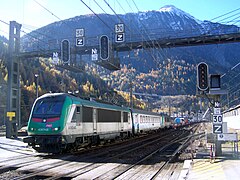
Arrival of a Modalohr train in Modane

TGV passing through Viviers
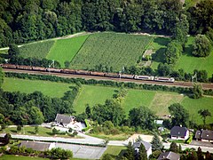
A freight train arrives in Montmélian .

Isère Bridge
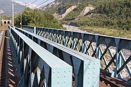
Resses Bridge over the Arc

Distance at km 164.149

Route at Chamousset

Route at Orelle


.jpg)

.JPG)


Web links
- Jacques Molinari: Caractéristiques d'infrastructures comparées des percées ferroviaires alpines franco-Italiennes: B - Contraintes constructives (génie civil & infrastructures lourdes) régissant les circulations sur la ligne de Modane. (PDF) December 1999, accessed on June 5, 2016 (French).
Individual evidence
- ^ Roger Ratel, Jean Prieur: Le tunnel ferroviaire du Fréjus: 1857-1995; le chemin de fer, son of evolution . Impr. Roux, 1996, OCLC 412481364 , pp. 86 .
- ↑ Alphonse Courtois: Des opérations de bourse: Manuel des fonds publics et des sociétés par actions dont les titres se négocient en France, en Belgique et en Suisse… Guillaumin et Cie, 1856, p. 344–345 ( books.google.de [accessed June 5, 2016]).
- ^ France Auteur du texte: Bulletin des lois de la République française. In: Gallica. July 1, 1863, Retrieved June 5, 2016 .
- ^ France Auteur du texte: Bulletin des lois de la République française. In: Gallica. July 1, 1867, accessed June 5, 2016 .
- ^ André Fournier and others: Dans la fureur des eaux, la Maurienne engloutie, juin 1957: 50e anniversaire, juin 1957 – juin 2007 . La Fontaine de Siloé, Montmélian 2008, ISBN 978-2-84206-388-7 , pp. 30 .
- ↑ Inondation en Maurienne . In: La Vie du Rail . No. 607 , 1957, OCLC 882693910 , pp. 15th ff .
- ↑ Philippe LM Matyus: Rail Savoie - les Inondations de 1957 en Maurienne. In: railsavoie.fr. Retrieved June 6, 2016 .
- ↑ Renseignements techniques SNCF / RFF - RT 5132 Ambérieu - Chambéry et RT 5133 Chambéry - Modane