Saint-André-le-Gaz
| Saint-André-le-Gaz | ||
|---|---|---|
|
|
||
| region | Auvergne-Rhône-Alpes | |
| Department | Isère | |
| Arrondissement | La Tour-du-Pin | |
| Canton | La Tour-du-Pin | |
| Community association | Les Vals du Dauphiné | |
| Coordinates | 45 ° 33 ' N , 5 ° 32' E | |
| height | 356-488 m | |
| surface | 8.89 km 2 | |
| Residents | 2,793 (January 1, 2017) | |
| Population density | 314 inhabitants / km 2 | |
| Post Code | 38490 | |
| INSEE code | 38357 | |
| Website | http://www.saintandrelegaz.fr/ | |
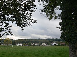
 View of Saint-André-le-Gaz |
||
Saint-André-le-Gaz is a French commune with 2,793 inhabitants (as of January 1 2017) in the department of Isère in the region Auvergne Rhône-Alpes . Administratively it belongs to the Arrondissement of La Tour-du-Pin and is part of the canton of La Tour-du-Pin . The inhabitants are called Saint-Andréens .
geography
Saint-André-le-Gaz is bounded to the north and east by the Bourbre river . Saint-André-le-Gaz is surrounded by the neighboring communities of La Bâtie-Montgascon in the north, Fitilieu in the east, Saint-Ondras in the south-east, Le Passage in the south and south-west and Saint-Didier-de-la-Tour in the north-west.
The Autoroute A43 runs along the northern municipal border.
Population development
| year | 1962 | 1968 | 1975 | 1982 | 1990 | 1999 | 2006 | 2012 |
| Residents | 1.311 | 1.406 | 1,526 | 1,641 | 1,903 | 1.961 | 2,291 | 2,605 |
Attractions
- Saint-André church with bell tower
- Verel Castle
Web links
Commons : Saint-André-le-Gaz - Collection of images, videos and audio files
