La Verpillière
| La Verpillière | ||
|---|---|---|

|
|
|
| region | Auvergne-Rhône-Alpes | |
| Department | Isère | |
| Arrondissement | La Tour-du-Pin | |
| Canton | La Verpillière (main town) | |
| Community association | Porte de l'Isère | |
| Coordinates | 45 ° 38 ' N , 5 ° 8' E | |
| height | 205-305 m | |
| surface | 6.64 km 2 | |
| Residents | 7,226 (January 1, 2017) | |
| Population density | 1,088 inhabitants / km 2 | |
| Post Code | 38290 | |
| INSEE code | 38537 | |
| Website | www.laverpilliere.eu/ | |
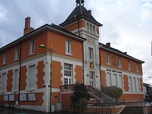
 La Verpillière Town Hall |
||
La Verpillière is a commune with 7226 inhabitants (as of January 1 2017) in Isère in the region Auvergne Rhône-Alpes ; administratively it belongs to the arrondissement of La Tour-du-Pin and is the main town ( chef-lieu ) of the canton of La Verpillière . The inhabitants are called Vulpillien (ne) s .
geography
la Verpillière is located about 24 kilometers east-southeast of Lyon . The Bourbre flows through the municipality . It is bounded to the north and east by the municipality of Frontonas , to the east and south by Villefontaine and to the south and west by Saint-Quentin-Fallavier .
Population development
| 1962 | 1968 | 1975 | 1982 | 1990 | 1999 | 2006 | 2011 | |
|---|---|---|---|---|---|---|---|---|
| 1,795 | 2,424 | 3,285 | 5,400 | 5,595 | 5,691 | 5,982 | 6,469 | |
| Sources: Cassini and INSEE | ||||||||
Partner communities
- Verolengo , Province of Turin (Piedmont), Italy.
traffic
The A 43 autoroute and the former National Route 6 run through the municipality .
Attractions
- church
- town hall
Web links
Commons : La Verpillière - Collection of images, videos and audio files

