
Trept
| Trept | ||
|---|---|---|
|
||
| region | Auvergne-Rhône-Alpes | |
| Department | Isère | |
| Arrondissement | La Tour-du-Pin | |
| Canton | Charvieu-Chavagneux | |
| Community association | Les Balcons du Dauphiné | |
| Coordinates | 45 ° 41 ′ N , 5 ° 19 ′ E | |
| height | 219-360 m | |
| surface | 15.87 km 2 | |
| Residents | 2,170 (January 1, 2017) | |
| Population density | 137 inhabitants / km 2 | |
| Post Code | 38460 | |
| INSEE code | 38515 | |
| Website | http://www.trept.fr/ | |
 Town hall (Mairie) of Trept |
||

Trept is a commune with 2,170 inhabitants (as of January 1 2017) in the department of Isère in the region Auvergne Rhône-Alpes . Trept is located in the Arrondissement of La Tour-du-Pin and in the canton Charvieu-Chavagneux (until 2015: canton Crémieu ). The inhabitants are called Treptois .
geography
Trept is about 39 kilometers east-southeast of Lyon . Trept is surrounded by the neighboring municipalities of Dizimieu in the north and northwest, Siccieu-Saint-Julien-et-Carisieu in the north, Soleymieu in the east and northeast, Salagnon in the southeast, Saint-Chef in the south and Saint-Hilaire-de-Brens in the west and Southwest.
Population development
| 1962 | 1968 | 1975 | 1982 | 1990 | 1999 | 2006 | 2012 |
|---|---|---|---|---|---|---|---|
| 817 | 840 | 853 | 1,039 | 1,164 | 1,540 | 1,688 | 1,836 |
| Source: Cassini and INSEE | |||||||
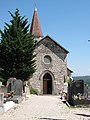
Attractions
- church
- Saint Didier Chapel in Cozance from the 15th century
- La Poype de Serrières Castle, castle and palace complex from the 14th / 15th centuries Century, since 1992 Monument historique
- old trainstation
- Wash house

church
Saint Didier Chapel

La Poype de Serrières Castle


Web links
Commons : Trept - collection of images, videos and audio files