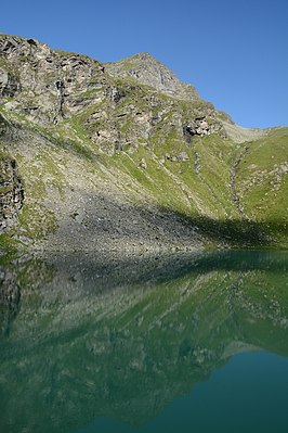
Hinterer Plattenkogel
| Hinterer Plattenkogel | ||
|---|---|---|
|
The mountain summit of the Hinterer Plattenkogel in front of the Löbbensee |
||
| height | 2741 m above sea level A. | |
| location | East Tyrol | |
| Mountains | Gschlößkamm , Venediger Group | |
| Dominance | 0.35 km → Wildenkogel | |
| Notch height | 51 m ↓ Scharte to Wildenkogel | |
| Coordinates | 47 ° 6 '35 " N , 12 ° 28' 4" E | |
|
|
||
| First ascent | unknown | |
The Hintere Plattenkogel ( 2741 m above sea level ) is a mountain peak in the Gschlößkamm of the Venediger group in the north of East Tyrol (municipality of Matrei in East Tyrol ).
location
The Hintere Plattenkogel is a summit in the far east of the Gschlößkamm between the Wildenkogel ( 3021 m above sea level ) in the southwest and the Vorderen Plattenkogel ( 2672 m above sea level ) in the northeast. The Hintere Plattenkogel is separated from the Vorderen Plattenkogel by the Plattenscharte ( 2563 m above sea level ) and from the Wildenkogel by an unnamed notch ( 2693 m above sea level ). Southeast of the Hinteren Plattenkogel lies the Wildensee , east of the Löbbensee . The Hintere Plattenkogel is insignificant from a mountaineering point of view; the Wildenkogelweg leads past it to the southeast.
Individual evidence
literature
- Willi End , Hubert Peterka : Alpine Club Leader Venediger Group. Bergverlag Rother , 5th edition 2006, ISBN 3-7633-1242-0 , p. 292.
- Alpine Club Map 1: 25,000, sheet 36, Venediger Group , ISBN 3-928777-49-1 .

