Löbbensee
| Löbbensee | ||
|---|---|---|

|
||
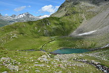
| Löbbensee from the south from the Wildenkogelweg | ||
| Geographical location | Tyrol , Austria | |
| Tributaries | from Wildensee | |
| Drain | Löbbenbach → Tauernbach | |
| Data | ||
| Coordinates | 47 ° 6 '25 " N , 12 ° 28' 38" E | |
|
|
||
| Altitude above sea level | 2226 m above sea level A. | |
| surface | 2.9 ha | |
| length | 245 m | |
| width | 160 m | |
The Löbbensee , also Lep'msee , is a mountain lake ( 2226 m above sea level ) in the Gschlößkamm of the Venediger group in the north of East Tyrol (municipality of Matrei in East Tyrol ).
The Löbensee is located in the east of the Gschlößkamm between the Vorderen Plattenkogel ( 2672 m above sea level ) in the northwest, the Hinteren Plattenkogel ( 2741 m above sea level ) in the west and the Spitzkogel ( 2606 m above sea level ) in the southeast. It is a cirque lake , the color of which is described as turquoise blue. The Löbbensee is mainly fed by the runoff from a slightly higher lying Lacke, which in turn takes up the runoff from the even higher situated Wildensee . In addition, the Löbbensee takes in a small stream that drains the slopes between the Hinteren and Vorderen Plattenkogel. The outflow of the Löbbensee takes place via the Löbbenbach to the Tauernbach .
The name of the Löbbensee is derived from the dialect word Leipen (Slovene lépen ), which means "large sheet" or perhaps also meant plate. The meaning of the name Löbbensee can therefore be assumed to be “Plattensee” or “Steinsee”. In an investigation in the 1980s, a population of arctic char was described in Löbbensee, with numerous lakes in the region being stocked with fish as early as the Middle Ages.
Individual evidence
- ↑ Alpine Club Map Venediger Group
- ↑ ÖK50
- ↑ Hohe Tauern National Park (ed.): Excursion report Gschlösstal. A cultural and scientific guide to the Hohe Tauern National Park. ( Page no longer available , search in web archives ) Info: The link was automatically marked as defective. Please check the link according to the instructions and then remove this notice. Matrei in Osttirol 2003, p. 30/62
- ^ Franz Waldmann: On the names of the Granatspitzkarte .. : Journal of the German Alpine Association / Journal of the German and (the) Austrian Alpine Association , year 1942, p. 78 (online at ANNO ).
- ↑ Robert Schabetsberger, Christand D. Jersabek, Brigitte Mooslechner: The fishing industry in the national park region between 1966 and 1994. In: Scientific releases from the National Park Hohe Tauern. Vol. 3, 1997, pp. 165-181
literature
- Willi End , Hubert Peterka : Alpine Club Leader Venediger Group. Bergverlag Rother , 5th edition 2006, ISBN 3-7633-1242-0 , p. 198.
- Alpine Club Map 1: 25,000, sheet 36, Venediger Group , ISBN 3-928777-49-1 .

