Val-de-Virieu
| Val-de-Virieu | ||
|---|---|---|
|
|
||
| region | Auvergne-Rhône-Alpes | |
| Department | Isère | |
| Arrondissement | Arrondissement of La Tour-du-Pin | |
| Canton | Le Grand Lemps | |
| Community association | Communauté de communes Les Vals du Dauphiné | |
| Coordinates | 45 ° 29 ′ N , 5 ° 29 ′ E | |
| height | 381-775 m | |
| surface | 16.26 km 2 | |
| Residents | 1,539 (January 1, 2017) | |
| Population density | 95 inhabitants / km 2 | |
| Post Code | 38730 | |
| INSEE code | 38560 | |
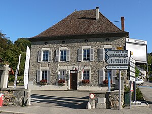
 Town hall of Val-de-Virieu |
||
Val-de-Virieu is a French commune with 1,539 inhabitants (as of January 1 2017) in the department of Isère in the region Auvergne Rhône-Alpes . It belongs to the Arrondissement of La Tour-du-Pin and the canton of Le Grand-Lemps .
It was created as Commune nouvelle with effect from January 1, 2019 through the amalgamation of the previous municipalities of Panissage and Virieu , which have the status of a Commune déléguée in the new municipality . The administrative headquarters are in Virieu.
structure
| District | former INSEE code |
Area (km²) | Population as of January 1, 2017 |
|---|---|---|---|
| Virieu (administrative headquarters) | 38560 | 11.38 | 1,093 |
| Panissage | 38293 | 4.88 | 446 |
geography
The municipality is located around 40 kilometers northwest of Grenoble in the valley of the Bourbre River . It has a train station on the Lyon – Marseille railway line . Neighboring communities are Doissin in the north-west, Chélieu in the north, Valencogne in the east, Villages du Lac de Paladru with Le Pin in the south-east, Oyeu and Burcin in the south, Châbons in the south-west and Blandin in the west.
Web links
Individual evidence
- ↑ Decree of the Prefecture No. 38-2018-10-11-008 on the formation of the Commune nouvelle Val-de-Virieu of October 11, 2018.
- ↑ current population according to INSEE
