Chèzeneuve
| Chèzeneuve | ||
|---|---|---|
|
|
||
| region | Auvergne-Rhône-Alpes | |
| Department | Isère | |
| Arrondissement | La Tour-du-Pin | |
| Canton | L'Isle-d'Abeau | |
| Community association | Porte de l'Isère | |
| Coordinates | 45 ° 34 ' N , 5 ° 13' E | |
| height | 400-529 m | |
| surface | 6.79 km 2 | |
| Residents | 596 (January 1, 2017) | |
| Population density | 88 inhabitants / km 2 | |
| Post Code | 38300 | |
| INSEE code | 38102 | |
| Website | http://www.chezeneuve.fr/ | |
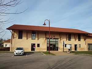
 Mairie Chézeneuve |
||
Chèzeneuve is a French municipality with 596 inhabitants (as of January 1 2017) in the department of Isère in the region Auvergne Rhône-Alpes ; administratively it belongs to the Arrondissement La Tour-du-Pin and is part of the canton L'Isle-d'Abeau .
geography
Chèzeneuve is located about 37 kilometers southeast of Lyon . Chèzeneuve is surrounded by the neighboring communities of Saint-Alban-de-Roche in the north, Domarin in the northeast, Maubec in the east, Crachier in the south, Artas in the southwest and Four in the west.
Population development
| 1962 | 1968 | 1975 | 1982 | 1990 | 1999 | 2006 | 2012 | |
|---|---|---|---|---|---|---|---|---|
| 257 | 247 | 234 | 306 | 339 | 373 | 475 | 515 | |
| Sources: Cassini and INSEE | ||||||||
Web links
Commons : Chèzeneuve - collection of images, videos and audio files

