
Burcin
| Burcin | ||
|---|---|---|

|
|
|
| region | Auvergne-Rhône-Alpes | |
| Department | Isère | |
| Arrondissement | La Tour-du-Pin | |
| Canton | Le Grand Lemps | |
| Community association | Bièvre Est | |
| Coordinates | 45 ° 26 ' N , 5 ° 26' E | |
| height | 453-734 m | |
| surface | 6.69 km 2 | |
| Residents | 423 (January 1, 2017) | |
| Population density | 63 inhabitants / km 2 | |
| Post Code | 38690 | |
| INSEE code | 38063 | |
| Website | http://www.burcin.fr/ | |
 City Hall (Mairie) of Burcin |
||

Burcin is a French municipality with 423 inhabitants (as of January 1 2017) in the department of Isère in the region Auvergne Rhône-Alpes ; administratively it belongs to the arrondissement of La Tour-du-Pin and is part of the canton of Le Grand-Lemps . The inhabitants are called Burcinois .
geography
Burcin is located about 45 kilometers east-southeast of Vienne . Burcin is surrounded by the neighboring communities of Châbons in the north and west, Val-de-Virieu with Virieu in the northeast, Oyeu in the east, Colombe in the south and Le Grand-Lemps in the southwest.
Population development
| 1962 | 1968 | 1975 | 1982 | 1990 | 1999 | 2006 | 2013 | |
|---|---|---|---|---|---|---|---|---|
| 317 | 334 | 303 | 318 | 401 | 370 | 428 | 414 | |
| Sources: Cassini and INSEE | ||||||||
Attractions
- 19th century Saint Martin church
- Notre-Dame-de-Milin chapel
- Komtur, later a permanent house from the 12th century, renovations from the 17th century
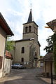
Saint Martin Church
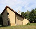
Notre-Dame-de-Milin chapel

Commander


Web links
Commons : Burcin - collection of pictures, videos and audio files