Tegernseebach
| Tegernseebach | ||
|
Tegernseebach at the golf course |
||
| Data | ||
| Water code | DE : 162992 | |
| location | Bavaria | |
| River system | Danube | |
| Drain over | Loisach → Isar → Danube → Black Sea | |
| source | at Egelsee 47 ° 50 ′ 36 ″ N , 11 ° 26 ′ 47 ″ E |
|
| Source height | approx. 613 m above sea level NHN | |
| muzzle | in the Loisach near Boschhof Coordinates: 47 ° 48 ′ 52 " N , 11 ° 24 ′ 49" E 47 ° 48 ′ 52 " N , 11 ° 24 ′ 49" E |
|
| Mouth height | 584 m above sea level NHN | |
| Height difference | approx. 29 m | |
| Bottom slope | approx. 4.4 ‰ | |
| length | 6.6 km | |
| Catchment area | 10.18 km² | |
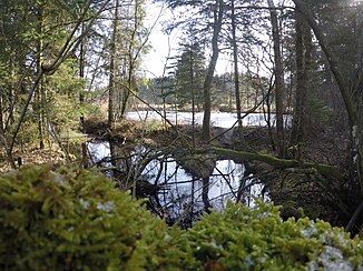
The Tegernseebach , also Tegernseegraben , on historical maps Tegernsee Bach , is a flowing body of water in the Bavarian district of Bad Tölz-Wolfratshausen . It arises at the Egelsee in the Babenstubener Moore nature reserve. From there the brook first flows south, turns near a golf course with several ponds connected to the brook via ditches, increasingly to the west and finally flows into the Loisach from the right .
Web links
Individual evidence
- ↑ a b List of brook and river areas in Bavaria - Isar river area, page 32 of the Bavarian State Office for the Environment, as of 2016 (PDF; 2.5 MB)
- ↑ NSG-00325.01

