
Vernas
| Vernas | ||
|---|---|---|
|
||
| region | Auvergne-Rhône-Alpes | |
| Department | Isère | |
| Arrondissement | La Tour-du-Pin | |
| Canton | Charvieu-Chavagneux | |
| Community association | Les Balcons du Dauphiné | |
| Coordinates | 45 ° 47 ' N , 5 ° 17' E | |
| height | 195-429 m | |
| surface | 5.87 km 2 | |
| Residents | 266 (January 1, 2017) | |
| Population density | 45 inhabitants / km 2 | |
| Post Code | 38460 | |
| INSEE code | 38535 | |
 Town Hall (Mairie) of Vernas |
||

Verna is a French municipality with 266 inhabitants (as of January 1 2017) in the department of Isère in the region Auvergne Rhône-Alpes . It belongs to the Arrondissement of La Tour-du-Pin and is part of the canton of Charvieu-Chavagneux . The inhabitants are called Vernandiaux .
geography
Vernas is located about 35 kilometers east-southeast of Lyon on the Rhône . Vernas is surrounded by the neighboring communities of Saint-Vulbas and Hières-sur-Amby in the north and northeast, Annoisin-Chatelans in the east and southeast, Leyrieu in the south and southwest, Saint-Romain-de-Jalionas in the southwest and Loyettes in the west.
Population development
| 1962 | 1968 | 1975 | 1982 | 1990 | 1999 | 2006 | 2013 | |
|---|---|---|---|---|---|---|---|---|
| 91 | 97 | 90 | 117 | 155 | 174 | 216 | 253 | |
| Sources: Cassini and INSEE | ||||||||
Attractions
- Saint Martin Church
- Le Cingle Castle from the 13th / 14th centuries Century, monument historique since 1975
- Verna Castle from the 14th century, monument historique since 1969
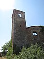
Saint Martin Church
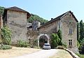
Le Cingle Castle


Web links
Commons : Vernas - collection of images, videos and audio files