
Villages du Lac de Paladru
| Villages du Lac de Paladru | ||
|---|---|---|
|
||
| region | Auvergne-Rhône-Alpes | |
| Department | Isère | |
| Arrondissement | La Tour-du-Pin | |
| Canton | Le Grand Lemps | |
| Community association | Pays Voironnais | |
| Coordinates | 45 ° 28 ' N , 5 ° 33' E | |
| height | 487-767 m | |
| surface | 21.24 km 2 | |
| Residents | 2,485 (January 1, 2017) | |
| Population density | 117 inhabitants / km 2 | |
| Post Code | 38850 | |
| INSEE code | 38292 | |

Villages du Paladru is a French commune with 2,485 inhabitants (as of January 1 2017) in the department of Isère in the region Auvergne Rhône-Alpes . It belongs to the arrondissement of La Tour-du-Pin and is part of the canton of Le Grand-Lemps .
structure
| District | former INSEE code |
Area (km²) | Population (2017) |
|---|---|---|---|
| Paladru (administrative headquarters) | 38292 | 11.64 | 1,234 |
| Le pin | 38305 | 9.60 | 1,251 |
geography
Villages du Lac de Paladru is located about 64 kilometers east-southeast of Lyon on the north and west side of Lac de Paladru .
Villages du Lac de Paladru is surrounded by nine neighboring communities:
| Valencogne |
Saint-Ondras Charancieu |
Les Abrets en Dauphiné |
.svg)
|
Montferrat | |
| Val-de-Virieu |
Charavines Oyeu |
Bilieu |
history
On January 1, 2017, the previously independent municipalities of Paladru and Le Pin were merged to form the Commune nouvelle Villages du Lac de Paladru.
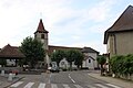
Attractions
Paladru
- Saint-Michel church
- Saint-Pierre church in the Saint-Pierre-de-Paladru district
- Notre-Dame chapel in the Les Trois-Croix district
- Marinière Castle
- Old castle from the 13th century

Le pin
- Saint-Christophe church from 1769
- Charterhouse of La Sylve-Bénite, founded in 1116
- Old tithe barn from 1549, reconstructed in 1658
Saint-Christophe Church

Old tithe barn


Web links
Commons : Villages du Lac de Paladru - Collection of images