
Chamagnieu
| Chamagnieu | ||
|---|---|---|

|
|
|
| region | Auvergne-Rhône-Alpes | |
| Department | Isère | |
| Arrondissement | La Tour-du-Pin | |
| Canton | La Verpillière | |
| Community association | Les Balcons du Dauphiné | |
| Coordinates | 45 ° 41 ′ N , 5 ° 10 ′ E | |
| height | 202-341 m | |
| surface | 13.7 km 2 | |
| Residents | 1,674 (January 1, 2017) | |
| Population density | 122 inhabitants / km 2 | |
| Post Code | 38460 | |
| INSEE code | 38067 | |
| Website | http://www.chamagnieu.com | |
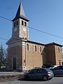
 Town hall (Mairie) of Chamagnieu |
||

Chamagnieu is a French commune with 1,674 inhabitants (as of January 1 2017) in the department of Isère in the region Auvergne Rhône-Alpes . Chamagnieu belongs to the Arrondissement La Tour-du-Pin and the canton La Verpillière (until 2015: canton Crémieu ). The inhabitants are called Chamagnard (e) s (or Chamagnolands ).
geography
Chamagnieu is located about 27 kilometers east-southeast of Lyon . Chamagnieu is surrounded by the neighboring communities of Tignieu-Jameyzieu in the north, Crémieu in the northeast, Chozeau in the east and northeast, Panossas in the east, Frontonas in the southeast, Saint-Quentin-Fallavier in the south and southwest, Satolas-et-Bonce in the west and Colombier- Saugnieu in the northwest.
Population development
| 1962 | 1968 | 1975 | 1982 | 1990 | 1999 | 2006 | 2013 |
|---|---|---|---|---|---|---|---|
| 404 | 432 | 514 | 817 | 1.010 | 1,180 | 1,437 | 1,476 |
| Source: Cassini and INSEE | |||||||
Attractions
- Saint-Christophe church from the 19th century
- Chamagnieu Castle
- Fixed houses of Chamagnieu, Bourcieu and Bellegarde, each from the 13th century
- Saint Clair Chapel in Mianges
Saint-Christophe Church

Saint Clair Chapel

Chamagnieu Castle


