Colombier-Saugnieu
| Colombier-Saugnieu | ||
|---|---|---|

|
|
|
| region | Auvergne-Rhône-Alpes | |
| Department | Rhône | |
| Arrondissement | Lyon | |
| Canton | Genas | |
| Community association | Est Lyonnais | |
| Coordinates | 45 ° 43 ' N , 5 ° 7' E | |
| height | 200-277 m | |
| surface | 27.62 km 2 | |
| Residents | 2,613 (January 1, 2017) | |
| Population density | 95 inhabitants / km 2 | |
| Post Code | 69124 | |
| INSEE code | 69299 | |
| Website | www.mairie-colombiersaugnieu.fr | |
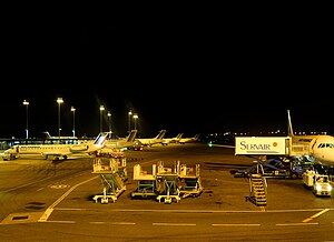
 Lyon Saint-Exupéry Airport |
||
Colombier-Saugnieu is a French commune with 2,613 inhabitants (at January 1, 2017) in the department of Rhône in the region of Auvergne Rhône-Alpes .
geography
Colombier-Saugnieu is the easternmost municipality in the Rhône department. It consists of three districts: Colombier , Saugnieu and Montcul . In the east, the municipality borders on the Isère department , to which it belonged until April 1, 1971. The border is the Bourbre .
traffic
Lyon Saint-Exupéry Airport is located in the municipality .
Population development
| year | 1962 | 1968 | 1975 | 1982 | 1990 | 1999 | 2010 |
| Residents | 726 | 772 | 942 | 1,127 | 1,833 | 2,083 | 2,261 |
age structure
31 percent of the population are 19 years old or younger. Three percent 75 years old or older.
Web links
Commons : Colombier-Saugnieu - collection of images, videos and audio files
Individual evidence
- ↑ http://www.mairie-colombiersaugnieu.fr/fr/information/36578/colombier-saugnieu
- ↑ Archived copy ( memento of the original dated December 1, 2008 in the Internet Archive ) Info: The archive link has been inserted automatically and has not yet been checked. Please check the original and archive link according to the instructions and then remove this notice.
