
Montrottier
| Montrottier | ||
|---|---|---|
.svg)
|
|
|
| region | Auvergne-Rhône-Alpes | |
| Department | Rhône | |
| Arrondissement | Lyon | |
| Canton | L'Arbresle | |
| Community association | Monts du Lyonnais | |
| Coordinates | 45 ° 47 ' N , 4 ° 28' E | |
| height | 460-851 m | |
| surface | 23.1 km 2 | |
| Residents | 1,385 (January 1, 2017) | |
| Population density | 60 inhabitants / km 2 | |
| Post Code | 69770 | |
| INSEE code | 69139 | |
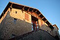
 View of Montrottier |
||

Montrottier is a French commune with 1,385 inhabitants (at January 1, 2017) in the department of Rhône in the region of Auvergne Rhône-Alpes . It belongs to the Arrondissement of Lyon and the Canton of L'Arbresle .
Neighboring communities
Neighboring municipalities of Montrottier are Saint-Forgeux in the north, Ancy in the northeast, Saint-Julien-sur-Bibost in the east, Brullioles in the south, Longessaigne in the southwest, Villechenève in the west and Affoux in the northwest.
Population development
| year | 1962 | 1968 | 1975 | 1982 | 1990 | 1999 | 2013 |
| Residents | 1,043 | 963 | 953 | 1,157 | 1,337 | 1,358 | 1,322 |
Attractions
- Portal of the former priory (15th century)
- Market halls from the time of Louis XIV.
- Saint-Sulpice church
- Rectory of Albigny on the site of the old castle
- Saint-Martin-les-Périls chapel (originally 12th century)

Saint-Sulpice church

Portal of the former priory
Market halls

Saint-Martin-les-Périls chapel


Web links
Commons : Montrottier - collection of images, videos and audio files