Limonest
| Limonest | ||
|---|---|---|

|
|
|
| region | Auvergne-Rhône-Alpes | |
| Department | Métropole de Lyon | |
| Arrondissement | Lyon | |
| Coordinates | 45 ° 50 ′ N , 4 ° 46 ′ E | |
| height | 275-603 m | |
| surface | 8.39 km 2 | |
| Residents | 3,664 (January 1, 2017) | |
| Population density | 437 inhabitants / km 2 | |
| Post Code | 69760 | |
| INSEE code | 69116 | |
| Website | mairie-limonest.fr | |
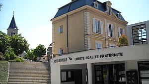
 town hall |
||
Limonest is a commune with 3664 inhabitants (at January 1, 2017) in the Métropole de Lyon in the region of Auvergne Rhône-Alpes . Administratively it belongs to the Arrondissement of Lyon and was the capital of the canton of Limonest of the same name until 2015 .
geography
The municipality in the metropolitan area around ten kilometers north of Lyon on the Mont d'Or hill chain , in the Coteaux du Lyonnais wine-growing region . Neighboring communities are:
- Chasselay in the north,
- Poleymieux-au-Mont-d'Or in the northeast,
- Saint-Didier-au-Mont-d'Or in the east,
- Champagne-au-Mont-d'Or in the south,
- Dardilly to the southwest and
- Lissieu in the northwest.
The municipality is supplied by the D42 département road, the A6 motorway runs to the west, from which a western bypass of Lyon is being planned.
Population development
| year | 1968 | 1975 | 1982 | 1990 | 1999 | 2006 |
|---|---|---|---|---|---|---|
| Residents | 1,751 | 1.941 | 2.131 | 2,459 | 2,733 | 3,007 |
Attractions
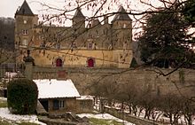
- Château de la Barollière , castle from the 14th century - Monument historique
Web links
Commons : Limonest - collection of images, videos and audio files
Individual evidence
- ↑ Château de la Barollière in the Base Mérimée of the French Ministry of Culture (French)

