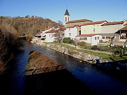
Saint-Romain-en-Gier
| Saint-Romain-en-Gier | ||
|---|---|---|
|
|
||
| region | Auvergne-Rhône-Alpes | |
| Department | Rhône | |
| Arrondissement | Lyon | |
| Canton | Mornant | |
| Community association | Vienne Condrieu | |
| Coordinates | 45 ° 34 ′ N , 4 ° 42 ′ E | |
| height | 175-325 m | |
| surface | 4.05 km 2 | |
| Residents | 579 (January 1, 2017) | |
| Population density | 143 inhabitants / km 2 | |
| Post Code | 69700 | |
| INSEE code | 69236 | |
 Town hall (Mairie) and school of Saint-Romain-en-Gier |
||
Saint-Romain-en-Gier is a French commune in the department of Rhône in the region of Auvergne Rhône-Alpes . It belongs to the arrondissement of Lyon and is part of the canton of Mornant (until 2015: canton of Givors ). Saint-Andéol-le-Château has 579 inhabitants (as of January 1, 2017) called Saint-Romanais .
geography
Saint-Romain-en-Gier is located about 23 kilometers south-southwest of Lyon am Gier . Saint-Romain-en-Gier is surrounded by the neighboring communities of Beauvallon in the north and west, Givors in the north-east, Échalas in the south and east, Trèves and Tartaras in the south-west and Dargoire in the west and south-west.
Saint-Romain-en-Gier is part of the Coteaux du Lyonnais wine region . The A47 autoroute runs through the municipality .
The community had a stop on the Moret-Veneux-les-Sablons-Lyon-Perrache railway line, which is no longer served today.
Population development
| year | 1962 | 1968 | 1975 | 1982 | 1990 | 1999 | 2006 | 2013 |
|---|---|---|---|---|---|---|---|---|
| Residents | 343 | 465 | 408 | 477 | 511 | 512 | 481 | 538 |
| Source: Cassini and INSEE | ||||||||
Attractions
- 19th century church


