Quincieux
| Quincieux | ||
|---|---|---|

|
|
|
| region | Auvergne-Rhône-Alpes | |
| Department | Métropole de Lyon | |
| Arrondissement | Lyon | |
| Coordinates | 45 ° 55 ' N , 4 ° 47' E | |
| height | 167-196 m | |
| surface | 17.72 km 2 | |
| Residents | 3,467 (January 1, 2017) | |
| Population density | 196 inhabitants / km 2 | |
| Post Code | 69650 | |
| INSEE code | 69163 | |
| Website | http://www.quincieux.fr/ | |
Quincieux is a commune with 3467 inhabitants (as of January 1 2017) in the Métropole de Lyon in the region of Auvergne Rhône-Alpes . It belongs to the arrondissement of Lyon and until 2015 to the canton of Neuville-sur-Saône . The inhabitants are called Quincerot (e) s .
geography
Quincieux is fifteen kilometers north of downtown Lyon on the western bank of the Saône . Quincieux is surrounded by the neighboring communities of Trévoux in the north, Reyrieux in the northeast, Parcieux in the east, Massieux and Saint-Germain-au-Mont-d'Or in the southeast, Chasselay in the south, Les Chères in the southwest, Lucenay in the west and Ambérieux in the west and northwest.
The A432 autoroute runs through the municipality . The municipality's train station is on the Paris – Marseille railway line .
In the south-east there is a large carport, which is partially covered with solar modules. The installed capacity is 8.7 MW.
Population development
| 1962 | 1968 | 1975 | 1982 | 1990 | 1999 | 2006 | 2011 | |
|---|---|---|---|---|---|---|---|---|
| 1,246 | 1,270 | 1,510 | 1,920 | 2,300 | 2,657 | 2,867 | 3.110 | |
| Sources: Cassini and INSEE | ||||||||
Attractions
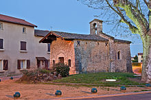
- Chapel in the district of La Chapelle from the 16th century, monument historique since 1983

