Marcy-l'Étoile
| Marcy-l'Étoile | ||
|---|---|---|

|
|
|
| region | Auvergne-Rhône-Alpes | |
| Department | Métropole de Lyon | |
| Arrondissement | Lyon | |
| Coordinates | 45 ° 47 ' N , 4 ° 42' E | |
| height | 233-369 m | |
| surface | 5.37 km 2 | |
| Residents | 3,657 (January 1, 2017) | |
| Population density | 681 inhabitants / km 2 | |
| Post Code | 69280 | |
| INSEE code | 69127 | |
| Website | www.marcyletoile.fr | |
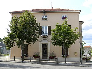
 Marcy-l'Étoile Town Hall |
||
Marcy-l'Étoile is a French municipality with 3657 inhabitants (as of January 1 2017) in the Métropole de Lyon in the region of Auvergne Rhône-Alpes . It belongs to the arrondissement of Lyon and formerly to the canton of Vaugneray . The inhabitants are called Marcyllois (es) .
geography
Marcy-l'Étoile is located about ten kilometers west-northwest of Lyon on the Ruisseau de Charbonnières stream . Marcy-l'Étoile is surrounded by La Tour-de-Salvagny in the north and north-east, Charbonnières-les-Bains in the east, Tassin-la-Demi-Lune in the south-east, Sainte-Consorce in the south and west and Lentilly in the north-west.
history
During the Middle Ages, the place was under the sovereignty of the Order of St. John and the Archbishop of Lyon. The pharmacological institute Mérieux emerged from the earlier (national) veterinary school from 1761, from which the biotechnology companies Sanofi Pasteur MSD and bioMérieux emerged in 1964 .
Population development
| year | 1962 | 1968 | 1975 | 1982 | 1990 | 1999 | 2006 | 2016 |
| Residents | 439 | 484 | 683 | 1,033 | 2,599 | 3,091 | 3,218 | 3,534 |
Attractions
- Saint-Pierre church in Marcy
- Lacroix-Laval Castle with park: Castle built in the 16th century, park (115 hectares), open to the public since 1985
Parish partnership
Marcy-l'Étoile has had a partnership with the German municipality of Weissach in Baden-Württemberg since 1998 .


