Lissieu
| Lissieu | ||
|---|---|---|

|
|
|
| region | Auvergne-Rhône-Alpes | |
| Department | Métropole de Lyon | |
| Arrondissement | Lyon | |
| Coordinates | 45 ° 52 ′ N , 4 ° 45 ′ E | |
| height | 199-367 m | |
| surface | 5.66 km 2 | |
| Residents | 3,122 (January 1, 2017) | |
| Population density | 552 inhabitants / km 2 | |
| Post Code | 69380 | |
| INSEE code | 69117 | |
| Website | http://www.lissieu.fr/ | |
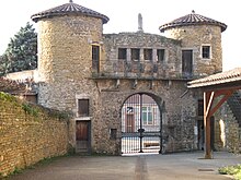
 Lissieu town hall |
||
Lissieu is a commune with 3122 inhabitants (as of January 1 2017) in the Métropole de Lyon in the region of Auvergne Rhône-Alpes . Administratively it belongs to the Arrondissement of Lyon and was part of the canton of Limonest until 2015 .
geography
Lissíeu is a banlieue in the north of Lyon on the Mont d'Or hill range , in the Coteaux du Lyonnais wine-growing region . Lissieu is surrounded by the neighboring communities of Les Chères in the north, Chasselay in the east and north-east, Limonest in the south and south-east, Dardilly in the south, Dommartin in the south-west and Marcilly-d'Azergues in the west and north-west.
The Autoroute A6 and the former Route nationale 6 (today's D306) run through the municipality .
Population development
| year | 1962 | 1968 | 1975 | 1982 | 1990 | 1999 | 2006 | 2011 |
|---|---|---|---|---|---|---|---|---|
| Residents | 481 | 597 | 734 | 2,091 | 2,535 | 3,090 | 3,307 | 3,049 |
Attractions
- Church from 1682
- Lissieu Castle
- Bois Dieu Castle
Parish partnership
There is a partnership with the Bagassi community in Burkina Faso.


