
Vignieu
| Vignieu | ||
|---|---|---|

|
|
|
| region | Auvergne-Rhône-Alpes | |
| Department | Isère | |
| Arrondissement | La Tour-du-Pin | |
| Canton | Morestel | |
| Community association | Les Balcons du Dauphiné | |
| Coordinates | 45 ° 38 ' N , 5 ° 26' E | |
| height | 220-444 m | |
| surface | 9.4 km 2 | |
| Residents | 1,015 (January 1, 2017) | |
| Population density | 108 inhabitants / km 2 | |
| Post Code | 38890 | |
| INSEE code | 38546 | |
| Website | vignieu.reseaudescommunes.fr/ | |
 Vignieu Town Hall |
||

Vignieu is a French commune with a population of 1,015 (as at 1st January 2017) in the department of Isère in the region Auvergne Rhône-Alpes . Vignieu is part of the La Tour-du-Pin arrondissement and the Morestel canton (until 2015: La Tour-du-Pin canton ). The inhabitants are called Vignolais .
geography
Vignieu is about 48 kilometers west-southwest of Lyon . Vignieu is surrounded by the neighboring communities of Sermérieu in the north, Vézeronce-Curtin in the northeast, Vasselin in the east, Dolomieu in the southeast, Montcarra in the south and Saint-Chef in the west.
Population development
| 1962 | 1968 | 1975 | 1982 | 1990 | 1999 | 2006 | 2012 | |
|---|---|---|---|---|---|---|---|---|
| 424 | 412 | 385 | 502 | 592 | 706 | 820 | 970 | |
| Source: Cassini and INSEE | ||||||||
Attractions
- Saint Blaise Church
- Chapeau cornu castle from the 14th century
- Giant fountain
- Fortified houses in Beauvenir

Saint Blaise Church
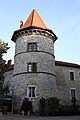
Tower of chapeau cornu castle


Web links
Commons : Vignieu - collection of images, videos and audio files