
Spindlerpass
| Spindlerpass / Przełęcz Karkonoska | |||
|---|---|---|---|
 The Spindlerpass in September 2010. |
|||
| Compass direction | North | south | |
| Pass height | 1198 m nm | ||
| Lower Silesia ( Poland ) | Královéhradecký kraj ( Czech Republic ) | ||
| Watershed | Czerwonka → Podgórna → Wrzosówka → Kamienna → Bober → Oder → Stettiner Haff | Bílé Labe → Elbe → North Sea | |
| Valley locations | Podgórzyn | Špindlerův Mlýn | |
| expansion | Pass road | ||
| Lock | North side for vehicles all year round | ||
| Mountains | Giant Mountains | ||
| profile | |||
| Ø pitch | 7.2% (891 m / 12.44 km) | 5.1% (486 m / 9.5 km) | |
| Max. Incline | 24% | 13% | |
| map | |||
|
|||
| Coordinates | 50 ° 45 '46 " N , 15 ° 38' 2" E | ||

The Spindlerpass ( Przełęcz Karkonoska in Polish ) is a mountain pass in the central Giant Mountains. It connects the Polish Podgórzyn ( Giersdorf ) with the Czech Špindlerův Mlýn ( Spindleruv Mlyn ). The watershed between the Elbe and the Oder and the state border between Poland and the Czech Republic run across the pass .
location
The main ridge of the Giant Mountains runs largely in a west-east direction and forms the border between Poland and the Czech Republic. The summit chain, also known as the “Prussian” or “Silesian ridge”, is divided almost exactly in the middle by the saddle on the Spindlerpass and the Mädelwiese into a western and an eastern half. Here the pass lies between the small balaclava (Polish Mały Szyszak , Czech Malý Šišák ) in the east and the Mädelsteinen (Polish Śląskie Kamienie , Czech Dívčí Kameny ) in the west.
Names
Shortly after the Second World War and the expulsion of the Sudeten German population, the pass was renamed “Przełęcz Szpindlerowska”. The current Polish name "Przełęcz Karkonoska" means " Rübezahls Pass". The mountain spirit is eponymous for the mountains in Polish and Czech; therefore it can also be translated as “Giant Mountains Pass”. Other than is sometimes read, there is no equivalent in Czech. The often mentioned " Slezské sedlo " is the Czech name for both passes or just for the pass at the Mädelwiese ( Przełęcz Dołek in Polish , translated as "Loch Pass"), which is a little over 500 meters to the west Meters is actually the deepest point of the ridge. Before the forest died out, this was the only place where the forest reached up to the ridge and reinforced the impression of a hole in the chain of peaks from the valley.
history
Until the 16th century
The saddle of the main ridge has probably always been known as the lowest point . The pass was certainly used by travelers who came over the Schlesierweg . This old trade route already connected Vrchlabí ( Hohenelbe ) with the Lower Silesian cities in the middle of the 12th century . The path made a decisive contribution to the settlement of the Giant Mountains and still crosses the pass today as the path of Polish-Czech friendship (ridge path ).
The first written records of Spindleruv Mlyn come from the first half of the 16th century, where silver and copper have been mined since 1516. Accordingly, the saddle on the Spindlerpass also gained more and more economic importance. With the Thirty Years' War mining came to a standstill and many people fled from marauding troops and for a long time the area was barely able to recover from the disaster.
In 1740, the Alte Erlebachbaude was finally built at an altitude of 1150 meters as the first hut on the Spindlerpass. Although the date is identical to the beginning of the First Silesian War , there is probably no connection. However, the difficult passable route over the saddle, controlled by the customs office in Friedrichsthal (today Bedrichov ), became essential for trade with Prussia . In 1784 the building was renovated, which is why other sources indicate this date as the year of foundation.
From the 19th century
The second largest of the buildings on the Spindlerpass is the Adolfbaude at 1200 meters above sea level. Originally it was called "Alte Spindlerbaude". In 1811 the building owner was the Friedrichsthal local judge Franz Spindler, a descendant of the master miller Franz Spindler, who was born in St. Peter in 1702 and from whose “Spindleruv Mlyn” the name of today's spa town is derived. Today it bears the name "Lužická bouda" ( Lusatian Baude )
The present Spindlerbaude was founded in 1824 . It stands at the top of the ridge at a height of 1208 meters and was built by the aforementioned judge Spindler.
From the 20th century
One hundred years later, next to the "Alte Erlebachbaude" ( Erlebachova ), the "Neue Erlebachbaude" was built in 1924 and was also called "Gabibaude" after its owner Gabriele Erlebach. In the meantime, all buildings have been expanded or rebuilt after a fire, such as the Spindlerbaude in 1885. Tourism had continued its triumphant advance since the 1830s and in 1929 the "Jugendkammhaus Rübezahl" was inaugurated as a youth hostel. Today, as a PTTK hostel, it bears the name “ Schronisko Odrodzenie ”, which can be translated as “Youth Hostel Resurrection”.
In 1914 the construction of the Czech section of the Spindlerpass road began, which was completed in autumn 1923 at a cost of 736,000 crowns up to the top of the pass. On the Silesian side, the expansion of the car route as a section of the Sudetenstrasse (Polish Droga Sudecka ) was planned for 1930. But there was no real progress with the measures. An interim result could only be achieved in 1937, when the road between Giersdorf and Baberhäuser (now Borowice ) , which had been laid out by the Graeflich Schaffgot Forest Administration in 1902–1904, was paved.

In 1938 National Socialist Germany annexed Czechoslovakia and it was decided to bring the project to an end. At the end of the thirties, construction began on the section from Baberhäuser towards the Spindlerpass. In 1939/40, a four-meter-wide, provisional driveway from the “Saftquetsche” in Hain (today Przesieka ) to the Spindlerbaude was completed. At the beginning of the Second World War , the prisoner-of-war camp “Command Stalag VIII A Forest Camp” was set up in Baberhäuser and its inmates were used during construction under inhumane conditions. In 1941, the entire length of the pass (15.5 km) from Hain to Spindleruv Mlyn was accessible by car.
During the construction work, many prisoners died of exhaustion and illness as a result of deliberate malnutrition and forced hard labor. Finally the construction project came to a halt again and the complete expansion of the Hain - Spindlerbaude section (6 km) had to be abandoned because of the approaching war front. The camp was dissolved and the remaining prisoners shot. The total number of victims is estimated at 800–1000 people.
After the end of the war, from around 1945 to 1948, the German residents of the Bauden on the Spindlerpass, along the pass road and in the surrounding area were evicted as part of the Beneš decrees and the buildings were converted into rest homes of the State Trade Union Confederation (ROH).
In 1959, due to the increasing tourism, a nature reserve was set up in Poland, the Karkonoski Park Narodowy ( KPN, Giant Mountains National Park ), which specifically placed the high and peaks of the mountains under protection. In 1963 what was then Czechoslovakia followed with the Krkonošský národní park ( KRNAP, Giant Mountains National Park ) and a similar protection program, from which the ridge region on the pass was not excluded and therefore had an impact on possible road construction plans.
In the 1970s, the construction of the missing sections was re-planned on the Polish side, but the project was stopped again and only the parts that had already been completed were re-asphalted. The following section of the route, which was never completed, is still paved for a length of about one kilometer from the intersection with the blue-marked hiking trail to Hain. This is followed by a path-like path that traces the planned hairpin turn to the northeast, and then joins the blue-marked hiking path along the provisional, now paved road. It is followed by a paved road to the northeast, which circles the mountain Sucha Góra. The top 1.5 kilometers before the actual Spindler Pass are then again developed as a wide farm road that crosses the provisional road again.
In 1989, the Velvet Revolution brought about a political turning point, in the course of which the previously state-run rest homes were re-privatized and transformed into modern sports hotels.
tourism
In addition to the buildings and hotels already mentioned, which go back to historical mining , the following should be mentioned: the Moravian cottage ( Moravská Bouda ), the Josefbaude ( Josefova bouda ) and the Peterbaude ( Petrova Bouda ), which burned down in 2011 and stood on the Mädelwiese.
The top of the pass and the parking lot for hikers can be reached by car or bus from Spindleruv Mlyn all year round, as the road is cleared in winter. The road on the Polish north side, on the other hand, is closed to car traffic all year round. It is one of the steepest roads in Poland with an average gradient of 7.2 and a maximum of 24 percent and although the road quality is very poor, the pass is very popular with mountain bikers and mountain bikers.
gallery

The Spindlerpass with a view of the small balaclava.

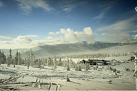
View from the small balaclava on the Spindlerpass in January 2005.
The Hotel Špindlerova Bouda at the Spindler pass. View from the small balaclava in January 2005.

Panorama on the Spindlerpass (from left to right: Spindlerbaude, former border guard and Schronisko Odrodzenie)


Web links
Individual evidence
- ↑ Frank Schüttig, Discovering the Riesengebirge, chap. Die Kammwanderung, p. 116, Trescher Verlag
- ↑ http://wincontact32naturwunder.blogspot.de/2013/10/wanderungen-am-riesengebirgskamm-teil-3.html Hikes on the Riesengebirgskamm
- ↑ a b c d e http://www.riesengebirge-plus.de/01_011.html Landscapes of the old homeland
- ↑ page at Riesengebirgler.de
- ↑ a b c http://www.borowice.pl/Droga_Sudecka Borowice website
- ↑ http://www.tenhumbergreinhard.de/05aaff9ee00f8073f/05aaff9ee00f9c841.html German prisoner of war camps