
Saint-Geoire-en-Valdaine
| Saint-Geoire-en-Valdaine | ||
|---|---|---|

|
|
|
| region | Auvergne-Rhône-Alpes | |
| Department | Isère | |
| Arrondissement | La Tour-du-Pin | |
| Canton | Chartreuse-Guiers | |
| Community association | Pays Voironnais | |
| Coordinates | 45 ° 27 ' N , 5 ° 38' E | |
| height | 364-739 m | |
| surface | 16.73 km 2 | |
| Residents | 2,399 (January 1, 2017) | |
| Population density | 143 inhabitants / km 2 | |
| Post Code | 38620 | |
| INSEE code | 38386 | |
| Website | http://www.saint-geoire-en-valdaine.com/fr/accueil/ | |
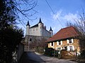
 Saint-Geoire-en-Valdaine Town Hall (former Montcla Castle) |
||

Saint-Geoire-en-Valdaine is a French commune with 2,399 inhabitants (as of January 1 2017) in the department of Isère in the region Auvergne Rhône-Alpes . Saint-Victor-de-Cessieu is part of the La Tour-du-Pin arrondissement and the Chartreuse-Guiers canton (until 2015: Saint-Geoire-en-Valdaine canton ). The inhabitants are called Saint-Geoirien (ne) s .
geography
Saint-Geoire-en-Valdaine is about 70 kilometers south-east of Lyon . Saint-Geoire-en-Valdaine is surrounded by the neighboring communities of Velanne in the north, Saint-Bueil in the northeast, Merlas in the east and southeast, Massieu in the south and southwest and Saint-Sulpice-des-Rivoires in the west.
Population development
| 1962 | 1968 | 1975 | 1982 | 1990 | 1999 | 2006 | 2012 |
|---|---|---|---|---|---|---|---|
| 1,341 | 1,333 | 1,351 | 1,570 | 1,819 | 1,979 | 2,271 | 2,393 |
Attractions
- Saint-Georges church, built in Gothic style in the 14th and 15th centuries, successor to the 12th century church, monument historique since 1907
- Longpra Castle, originally built as a fortified house in the 14th century, converted into a residence in 1770, monument historique since 1997
- Clermont Castle
- La Rochette Castle
- Montcla Castle, today's town hall
- Lambertière Castle
- Cabarot Castle
- L'Etergne Castle

Saint-Georges church

Longpra Castle
La Rochette Castle


Personalities
- Guillaume Dode de la Brunerie (1775–1851), Marshal of France
Web links
Commons : Saint-Geoire-en-Valdaine - Collection of images, videos and audio files