
Chassignieu
| Chassignieu | ||
|---|---|---|
|
||
| region | Auvergne-Rhône-Alpes | |
| Department | Isère | |
| Arrondissement | La Tour-du-Pin | |
| Canton | Le Grand Lemps | |
| Community association | Les Vals du Dauphiné | |
| Coordinates | 45 ° 30 ′ N , 5 ° 30 ′ E | |
| height | 373-607 m | |
| surface | 5.17 km 2 | |
| Residents | 232 (January 1, 2017) | |
| Population density | 45 inhabitants / km 2 | |
| Post Code | 38730 | |
| INSEE code | 38089 | |
 Town hall (Mairie) of Chassignieu |
||

Chassignieu is a French municipality with 232 inhabitants (as of January 1 2017) in the department of Isère in the region Auvergne Rhône-Alpes ; administratively it belongs to the arrondissement of La Tour-du-Pin and is part of the canton of Le Grand-Lemps (until 2015: canton of Virieu ).
geography
Chassignieu is located about 60 kilometers east-southeast of Lyon . The Bourbre delimits the municipality to the northwest. Chassignieu is surrounded by the neighboring communities of Le Passage in the north, Valencogne in the south and east, and Chélieu in the west and northwest.
Population development
| 1962 | 1968 | 1975 | 1982 | 1990 | 1999 | 2006 | 2013 | |
|---|---|---|---|---|---|---|---|---|
| 252 | 239 | 198 | 190 | 188 | 192 | 202 | 208 | |
| Sources: Cassini and INSEE | ||||||||
Attractions
- Notre-Dame-de-l'Assomption Church, built in 1894
- Bellegarde Palace, Monument historique since 1996

Notre-Dame-de-l'Assomption church
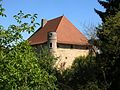
Bellegarde Palace


Web links
Commons : Chassignieu - collection of images, videos and audio files