
Loyettes
| Loyettes | ||
|---|---|---|
_(potenc%C3%A9e).svg)
|
|
|
| region | Auvergne-Rhône-Alpes | |
| Department | Ain | |
| Arrondissement | Belley | |
| Canton | Lagnieu | |
| Community association | Plaine de l'Ain | |
| Coordinates | 45 ° 47 ' N , 5 ° 12' E | |
| height | 185-204 m | |
| surface | 21.28 km 2 | |
| Residents | 3,146 (January 1, 2017) | |
| Population density | 148 inhabitants / km 2 | |
| Post Code | 01360 | |
| INSEE code | 01224 | |
| Website | www.commune-loyettes.fr | |
 Loyettes Town Hall |
||

Loyettes is a French municipality with 3146 inhabitants (as of January 1 2017) in the department of Ain in the region Auvergne Rhône-Alpes . It belongs to the Arrondissement Belley and is part of the Canton of Lagnieu . The residents call themselves Loyettains .
geography
Loyettes lies at the foot of the most south-westerly foothills of the Jura on the Rhône . The Ain flows on the northern edge of the municipality . Loyettes is surrounded by the neighboring communities of Saint-Jean-de-Niost in the north, Saint-Vulbas in the east and northeast, Vernas in the east, Saint-Romain-de-Jalionas in the south and southeast, Chavanoz in the west and southwest, Anthon in the west as well Saint-Maurice-de-Gourdans in the north-west.
Population development
| year | 1962 | 1968 | 1975 | 1982 | 1990 | 1999 | 2006 | 2017 |
| Residents | 792 | 1001 | 1453 | 1713 | 2256 | 2322 | 2418 | 3146 |
Attractions
- Saint-Jean-et-Saint-Christophe church
- Loyettes bridge over the Rhône
- Port-Galland bridge over the Ain
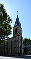
Saint-Jean-et-Saint-Christophe church

Bridge of the Loyettes


Parish partnership
A partnership has existed with the Belgian municipality of Loyers in Wallonia since 1990 .