Ruffieu
| Ruffieu | ||
|---|---|---|
|
|
||
| region | Auvergne-Rhône-Alpes | |
| Department | Ain | |
| Arrondissement | Belley | |
| Canton | Hauteville-Lompnes | |
| Community association | Bugey Sud | |
| Coordinates | 46 ° 0 ′ N , 5 ° 40 ′ E | |
| height | 605-1,195 m | |
| surface | 14.03 km 2 | |
| Residents | 186 (January 1, 2017) | |
| Population density | 13 inhabitants / km 2 | |
| Post Code | 01260 | |
| INSEE code | 01330 | |
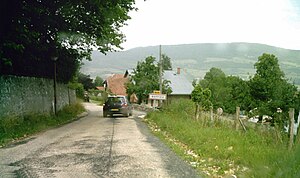
 Entrance to Ruffieu |
||
Ruffieu is a French municipality with 186 inhabitants (at January 1, 2017) in the department of Ain in the region Auvergne Rhône-Alpes . It belongs to the canton of Hauteville-Lompnes and the Arrondissement Belley .
geography
Ruffieu is located at 728 m , about 26 kilometers north of the city of Belley and 41 km southeast of the prefecture of Bourg-en-Bresse (as the crow flies). The farming village extends in the southeast of Bugey , in a panoramic position on the western slope of the Séran , in the valley of the Valromey , at the eastern foot of the ridge extending northwards from the Planachat .
The area of 14.03 km² large municipal area includes a section of the Valromey. The Valromey forms a wide depression between two high Jura ridges oriented in a north-south direction . The eastern municipal boundary runs along the Séran, which flows south in the open valley of the upper Valromey. From the course of the river, the community area extends westward over the slope of Ruffieu to the subsequent wide ridge, which is mostly covered by forest. Ruffieu's highest point is reached at 1199 m on a knoll in the Bois de la Valorse .
Ruffieu includes the hamlet of Préoux ( 690 m ) in the Séran valley and a few farms. Neighboring parishes of Ruffieu are
- Haut-Valromey with Le Petit-Abergement , Le Grand-Abergement , Hotonnes and Songieu in the north and in the east,
- Valromey-sur-Séran with Lompnieu in the south,
- Plateau d'Hauteville with Hauteville-Lompnes in the southwest,
- Champdor-Corcelles with Champdor to the west.
history
The municipality of Ruffieu was already populated during Roman times.
The place was first mentioned in 1135 under the name Rufiacus . Later the names Rufeu (1267), Ruffiacus and Ruffiou (1345) appeared. The place name goes back to the Gallo-Roman personal name Ruffius and means something like Ruffius' estate .
From the time it was first mentioned, Ruffieu formed a parish that was dependent on Ceyzérieu . In the Middle Ages, the village belonged to the rule of Valromey, which was under the sovereignty of the Counts of Savoy . With the Treaty of Lyon , Ruffieu came to France in 1601.
Attractions
The parish church of Saint-Didier originally dates from the 12th century, but was largely rebuilt in the 17th century. Various traditional style farmhouses from the 17th to 19th centuries have been preserved in the old town center.
population
| Population development | |
|---|---|
| year | Residents |
| 1962 | 243 |
| 1968 | 232 |
| 1975 | 187 |
| 1982 | 162 |
| 1990 | 144 |
| 1999 | 188 |
| 2006 | 172 |
| 2014 | 187 |
With 186 inhabitants (as of January 1, 2017) Ruffieu is one of the small communities in the Ain department. After the number of inhabitants had decreased significantly in the first half of the 20th century, it has remained constant since the beginning of the 1990s. The local residents of Ruffieu are called Ruffiolan (e) s in French .
Economy and Infrastructure
Until well into the 20th century, Ruffieu was a village dominated by agriculture and forestry. In addition, there are now some local small businesses. In the meantime, thanks to its beautiful location, the village has also turned into a residential community. Many workers are commuters who work in the larger towns in the area.
The village is located away from the major thoroughfares on a department road that leads from Artemare to Brénod . Further road connections exist with Hotonnes and via the Col de la Rochette with Hauteville-Lompnes.
Personalities
- Sandrine Bailly (* 1979), French biathlete, overall World Cup winner 2005 and multiple medalists at the Olympic Games and World Championships, lives in the village.
Web links
Individual evidence
- ^ André Buisson: Carte Archéologique de la Gaule - Ain 01 . Académie des Inscriptions et Belles-Lettres , 1990, ISBN 2-87754-010-3 , pp. 67 (French, limited preview in Google Book search).
- ↑ a b É. Philipon: Dictionnaire Topographique du Département de l'Ain . Imprimerie Nationale, 1911, p. 364 (French, online [PDF; accessed January 4, 2014]).
- ^ Ruffieu - notice communal. In: cassini.ehess.fr. Retrieved on June 14, 2015 (French, INSEE population from 1968 ).
