Tenay
| Tenay | ||
|---|---|---|

|
|
|
| region | Auvergne-Rhône-Alpes | |
| Department | Ain | |
| Arrondissement | Belley | |
| Canton | Hauteville-Lompnes | |
| Community association | Plaine de l'Ain | |
| Coordinates | 45 ° 55 ' N , 5 ° 31' E | |
| height | 320-1,020 m | |
| surface | 13.12 km 2 | |
| Residents | 1,035 (January 1, 2017) | |
| Population density | 79 inhabitants / km 2 | |
| Post Code | 01230 | |
| INSEE code | 01416 | |
| Website | www.mairie-tenay.fr | |
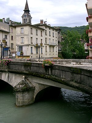
 Tenay town center with the bridge over the Albarine |
||
Tenay is a French commune with 1,035 inhabitants (at January 1, 2017) in the Ain department in the region of Auvergne Rhône-Alpes . It belongs to the canton of Hauteville-Lompnes and the Arrondissement Belley .
geography
Tenay is located at 367 m in the south of the French Jura in the Bugey countryside , 23 kilometers northwest of the town of Belley and about 55 kilometers east of Lyon (as the crow flies). Neighboring municipalities of Tenay are Évosges and Chaley in the north, Plateau d'Hauteville in the east, La Burbanche and Arandas in the south and Argis in the west.
The village sits at the bottom of one of the transverse Jura valleys , the Cluse des Hôpitaux . It extends on both sides of the Albarine , which at this point emerges from a ravine-like incised side valley ( Reculée ) and continues to flow west in the Cluse des Hôpitaux. The 13.12 km 2 municipal area includes the lower end of this Reculée and a section of the Cluse des Hôpitaux, with the eastern municipal boundary strictly following the upper edge that delimits the Hauteville plateau. The wooded valley flank, criss-crossed by rock walls, rises up to 600 m above the valley floor on this side and forms the highest point on the municipal floor.
In addition to the actual village, Tenay has two other hamlets:
- Malix (420– 500 m ) about 100 m above the Albarine,
- Le Chanay ( 741 m ) on the comparatively gently rising slope north of Tenay.
history
In the cave grotte de Treffiez on the eastern flank of the valley, excavations during the 1950s and 1960s have found a continuous sequence of layers with artefacts from Roman times back to the Latène times .
Tenay was first mentioned in 1130 as part of the lands of the powerful Benedictine Abbey of Saint-Rambert . Their territory, raised to margraviate in 1576 , came to France with the Treaty of Lyon in 1601.
The connection to the railway network in 1857 via the Lyon – Genève railway , which runs through the Cluse des Hôpitaux, enabled rapid industrialization and resulted in a tripling of the population within a few decades. Above all textile factories and bleaching plants were built . At the height of development, the construction of a tramway from Tenay to Hauteville began in 1909 , the route of which was to run along the western flank of the Reculée de l'Albarine and for which 18 successive tunnels were dug. However, the work was interrupted with the beginning of the First World War and finally stopped in 1936 without a train ever using the route.
Attractions
The parish church of Saint-André dates from the 19th century. The topography of the narrow Cluse des Hôpitaux already offers a sight that presents itself from various views along the towering valley edges. The former tram route is now accessible as a hiking trail.
A via ferrata set up in 2013 crosses a steep wall several hundred meters wide above the La Guinguette district .
Population development
| year | 1962 | 1968 | 1975 | 1982 | 1990 | 1999 | 2006 | 2011 |
| Residents | 2.132 | 1.993 | 1,715 | 1,571 | 1,356 | 1,086 | 1,100 | 1.103 |
With 1035 inhabitants (as of January 1, 2017) Tenay is one of the smaller communities in the Ain department. After the number of inhabitants had continuously decreased throughout the 20th century (in 1901 there were 3770 inhabitants), it has stagnated since 2000. The local residents of Tenay are called Tenaysien (ne) s in French .
Economy and Infrastructure
Despite its somewhat isolated location in rural Bugey, Tenay is an industrial village with several factory buildings along the narrow valley floor. About a third of the residents work in the village itself, the largest employer is Présentoir Seiller , a manufacturer of supermarket shelves and sales stands. A regional nursing home also offers jobs. Agriculture, on the other hand, is of no importance due to the difficult topography.
The place is on the D1504 departmental road, which runs through the Cluse des Hôpitaux and connects the town of Ambérieu-en-Bugey with Belley and Chambéry . This thoroughfare bypasses the narrow town center, from which a road to Hauteville-Lompnes begins through the Albarine gorge. The Tenay-Hauteville station on the Lyon-Geneva railway line is served by regional express trains. A connection to the next motorway ( A42 ) is around 25 km away.
Tenay has a state pre-school ( école maternelle ) and a state primary school ( école élémentaire ).
Web links
Individual evidence
- ^ André Buisson: Carte Archéologique de la Gaule - Ain 01 . Académie des Inscriptions et Belles-Lettres , 1990, ISBN 2-87754-010-3 , pp. 133 (French, limited preview in Google Book search).
- ↑ É. Philipon: Dictionnaire Topographique du Département de l'Ain . Imprimerie Nationale, 1911, p. 424 (French, online [PDF; accessed January 4, 2014]).
- ↑ a b Tenay - notice communal. In: cassini.ehess.fr. Retrieved on March 18, 2014 (French, INSEE population from 1968 ).
- ↑ French Statistics Institute ( www.insee.fr )


