
Virignin
| Virignin | ||
|---|---|---|
|
||
| region | Auvergne-Rhône-Alpes | |
| Department | Ain | |
| Arrondissement | Belley | |
| Canton | Belley | |
| Community association | Bugey Sud | |
| Coordinates | 45 ° 43 ' N , 5 ° 43' E | |
| height | 220-605 m | |
| surface | 7.88 km 2 | |
| Residents | 1,097 (January 1, 2017) | |
| Population density | 139 inhabitants / km 2 | |
| Post Code | 01300 | |
| INSEE code | 01454 | |

Virignin is a French commune in the Ain department in the region of Auvergne Rhône-Alpes . It belongs to the canton of Belley in the arrondissement of the same name . The residents call themselves the Virignolans.
geography
The Route nationale 504 A leads via Virignin. The border with Brens to the west runs largely along the Canal de Derivation du Rhône . This artificial body of water, which branches off from the Rhône, flows into the river coming from the east and then running south at the municipal triangle Brens / Virignin / La Balme . The other neighboring communities are Belley in the north, Parves-et-Nattages in the east and Yenne in the southeast. The municipality marker contains approved vineyards of the Vin du Bugey .
Population development
| year | 1962 | 1968 | 1975 | 1982 | 1990 | 1999 | 2008 | 2014 |
|---|---|---|---|---|---|---|---|---|
| Residents | 393 | 394 | 417 | 517 | 550 | 643 | 798 | 1,054 |
Attractions
- Pierre-Châtel bridge , built in 1226 to replace a bridge from ancient times
- former Pierre-Châtel Charterhouse , existing from 1388 to 1791, Monument historique
- Fort-les-Bancs

The former Pierre-Châtel Charterhouse

The Fort-les-Bancs
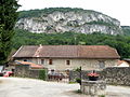
House in the district of La Saume


