Armix
| Armix | ||
|---|---|---|
|
|
||
| region | Auvergne-Rhône-Alpes | |
| Department | Ain | |
| Arrondissement | Belley | |
| Canton | Hauteville-Lompnes | |
| Community association | Bugey Sud | |
| Coordinates | 45 ° 51 ' N , 5 ° 35' E | |
| height | 420-1,064 m | |
| surface | 6.82 km 2 | |
| Residents | 28 (January 1, 2017) | |
| Population density | 4 inhabitants / km 2 | |
| Post Code | 01510 | |
| INSEE code | 01019 | |
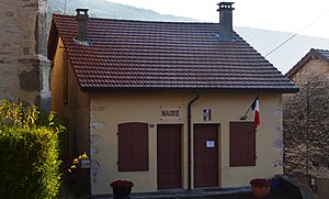
 Mairie Armix |
||
Armix is a French municipality with 28 inhabitants (at January 1, 2017) in the department of Ain in the region Auvergne Rhône-Alpes . It belongs to the canton of Hauteville-Lompnes in the Arrondissement Belley and is a member of the Bugey Sud community association .
geography
Armix is located at 720 m , about 21 kilometers southeast of the city of Ambérieu-en-Bugey and 48 km southeast of the prefecture of Bourg-en-Bresse (beeline). The small farming village extends in the central Bugey , on a south-sloping slope in the High Jura , high above the deeply cut Cluse des Hôpitaux, which, as a valley breakthrough, ensures the transport connection for railways and roads between Ambérieu-en-Bugey and Culoz .
The area of the 6.82 km² large municipality covers a section of the southern French Jura. The central part is taken up by the shoulder of the slope of Armix, which slopes to the south. It descends towards the southwest with a striking rock face to the Cluse des Hôpitaux ; the limit is above the edge of the rock. To the northeast, the community area extends to the wooded Jura ridge of the Forêt de Ravière , on which Armix's highest elevation is reached at 1064 m .
Neighboring municipalities to Armix are Prémillieu and Thézillieu in the north, Virieu-le-Grand in the east, Rossillon in the south and La Burbanche in the west.
history
Armix was first mentioned in a document in the 12th century under the name Armies . The village church was initially subordinate to the monastery of Cluny , later to the Cistercian monastery of Saint-Sulpice (near Thézillieu). Since the Middle Ages, the village has been under the sovereignty of the Counts of Savoy. With the Treaty of Lyon it came to France in 1601.
Attractions
The village church of Sainte-Catherine dates from the 19th century.
population
| Population development | |
|---|---|
| year | Residents |
| 1962 | 54 |
| 1968 | 48 |
| 1975 | 33 |
| 1982 | 28 |
| 1990 | 14th |
| 1999 | 15th |
| 2006 | 25th |
| 2011 | 20th |
With 28 inhabitants (as of January 1, 2017) Armix is the smallest of the 419 municipalities in the Ain department. Due to its remoteness, the village experienced a significant population decline due to heavy emigration during the 20th century, from which it has gradually been recovering since the beginning of the 21st century. The local people of Armix are called Armixois (es) in French .
Economy and Infrastructure
Armix was a predominantly agricultural and forestry village well into the 20th century . Even today, the residents live mainly from their work in the first sector. There are no other jobs in the village outside of the primary sector.
The village is located away from the larger thoroughfares. The main access is from Rossillon on the main road N504 through the Cluse des Hôpitaux. Another road connection is with Prémillieu.
Web links
Individual evidence
- ↑ French Statistics Institute ( www.insee.fr )
- ^ Armix - notice communal. In: cassini.ehess.fr. Retrieved June 10, 2015 (French, INSEE population from 1968 ).
