
Brégnier cordon
| Brégnier cordon | ||
|---|---|---|
|
||
| region | Auvergne-Rhône-Alpes | |
| Department | Ain | |
| Arrondissement | Belley | |
| Canton | Belley | |
| Community association | Bugey Sud | |
| Coordinates | 45 ° 39 ′ N , 5 ° 37 ′ E | |
| height | 203-460 m | |
| surface | 11.60 km 2 | |
| Residents | 839 (January 1, 2017) | |
| Population density | 72 inhabitants / km 2 | |
| Post Code | 01300 | |
| INSEE code | 01058 | |
 Brégnier-Cordon with the Saint-Jean-Baptiste church |
||

Brégnier-Cordon is a French commune in the Ain department in the region of Auvergne Rhône-Alpes . It belongs to the canton of Belley in the arrondissement of the same name .
geography
Brégnier-Cordon is the southernmost municipality in the Ain department. The north-western neighboring municipality is Groslée-Saint-Benoît with the Commune déléguée Saint-Benoît , which shares the hamlet of Glandieu with Brégnier-Cordon. Brégnier-Cordon also borders on Prémeyzel in the northeast, Izieu in the east, Champagneux in the southeast, Saint-Genix-les-Villages with Saint-Genix-sur-Guiers in the south, Aoste in the southwest and Les Avenières Veyrins-Thuellin with Les Avenières to the west.
Population development
| year | 1962 | 1968 | 1975 | 1982 | 1990 | 1999 | 2008 | 2014 |
|---|---|---|---|---|---|---|---|---|
| Residents | 582 | 502 | 442 | 502 | 511 | 566 | 746 | 861 |
economy
In Brégnier-Cordon there is a run-of-river power plant on the Rhône . For this purpose, the river is dammed in the east of Murs-et-Gélignieux . A canal starting from this runs through the Brégnier Cordon. The natural course forms the border with the Isère department in the south and west .
Attractions
- The Bronze Age or Iron Age dugout canoe from Brégnier-Cordon is exhibited in the Musée Escale Haut-Rhône.
- Lievrin Cave, a monument historique

Waterfall at Glandieu

Lac Glandieu

Saint-Jean-Baptiste church

open air museum
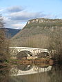
Bridge in cordon

Castle ruins in Cordon

Barre Castle

Medieval houses in the Brégnier district


.JPG)


Individual evidence
- ↑ https://www.20minutes.fr/lyon/713267-20110426-lyon-lyon-pirogue-millenaire-installee-parc-tete-or-rapatriee-musee-ain